
Year first constructed 1794 Construction stone tower Opened 1794 Focal height 52 m | Year first lit 1820s rebuilt Height 36 m Range 42,596 m Automated 1994 | |
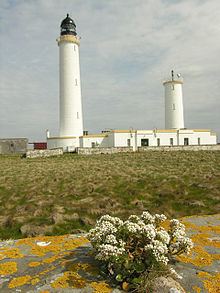 | ||
Location Muckle SkerryPentland SkerriesOrkneyScotlandUnited Kingdom Tower shape cylindrical tower with balcony and lantern Markings / pattern white tower, black lantern, ochre trim Similar Helliar Holm, Noup Head Lighthouse, Cantick Head Lighthouse, Graemsay, Muckle Flugga Lighthouse | ||
Muckle Skerry is the largest of the Pentland Skerries that lie off the north coast of Scotland. It is home to the Pentland Skerries Lighthouse.
Contents
Map of Muckle Skerry, United Kingdom
Muckle Skerry lies in the Pentland Firth at grid reference ND464782. It is the westernmost of the skerries. At one kilometre (three-fifths of a mile) long and rising to a height of 20 metres (66 feet) above sea level is sizable enough to be considered an island. However the notoriously bad weather of the firth has historically rendered Muckle Skerry uninhabitable and as such it is more often thought of as a skerry.
Pentland Skerries Lighthouse
Pentland Skerries Lighthouse was constructed in 1794 by the Commissioners of the Northern Lights. The engineers were Thomas Smith and his stepson Robert Stevenson (this was the first light that Stevenson officially worked on).