
Norse name Grímsey OS grid reference HY255055 Automated 1978 Lieutenancy area Orkney Island groups British Isles, Orkney | Meaning of name Grímr's Island Area rank 76 Area 4.09 km² Council area Orkney Year first constructed 1851 | |
 | ||
Highest elevation West Hill 62 m (203 ft) Similar Davaar Island, Out Skerries, Broch of Mousa, RNAS Hatston, Kerrera | ||
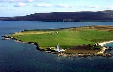
Graemsay is an island in the western approaches to Scapa Flow, in the Orkney Islands of Scotland. The island has two lighthouses.
Contents
- Map of Graemsay United Kingdom
- Geography and geology
- Wildlife
- History
- Lighthouses
- Book about the History of Graemsay
- References
Map of Graemsay, United Kingdom
Geography and geology
Graemsay lies between Hoy and Stromness on Mainland Orkney, separated from the Mainland by Clestrain Sound. The island is 409 ha (1.58 sq mi) in area and is mainly crofted.
The island's geology is Old Red Sandstone of the Devonian period, with two volcanic faults. On the north coast there is granite-schist, a great rarity in Orkney.
Graemsay is surrounded by strong tidal races, known locally as roosts. An Orkney Ferries service, usually operated by MV Graemsay, links the island with Stromness and Moaness on Hoy.
Graemsay is sometimes referred to locally, as 'Orkney's green isle' due to its lush green vegetation cover.
Wildlife
Birds include oystercatchers, ringed plovers, redshank and curlew. Parts of the island are largely undeveloped and are a haven for wild plants.
History
As with many other Orkney Islands, there is a connection to the Celtic Church, possibly a pre-Norse one. There are the remains of two early churches, dedicated to St Bride and to St Columba., who are both saints of Irish origin.
The island has two lighthouses, Hoy High (NE) and Hoy Low (NW), both built in 1851 by Alan Stevenson for the 19th-century herring industry.
At the Point of Oxan in the far north west, in Burra Sound, are block ships, which were scuttled deliberately during World War II. This is a common feature of the straits and former straits around Scapa Flow
The primary school closed in 1996 and the island's children travel daily by boat to school in Stromness on the ferry 'Graemsay.'
Lighthouses
Two lighthouses are present on Graemsay: Hoy Sound Low and Hoy Sound High located at the extremities of the northern side of the island. The lights were built in 1851 on project by Alan Stevenson; both are cylindrical tower with balcony and lantern, even if of different heights, white painted with black lantern and the typical ochre trims.
The Hoy High Light, known as Graemsay Island Range Rear, is 33 metres (108 ft) high and has a white and red occulting light every 8 seconds depending on the directions.
The Hoy Low Light (Graemsay Island Range Front) is 12 metres (39 ft) high and is distinguished by a white isophase light every 3 seconds. The two Range lighthouses direct the ships towards the Hoy Sound from the Atlantic.