
Website www.mubende.go.ug Area 4,645 km² | Region Central Uganda Time zone EAT (UTC+3) Elevation 1,300 m | |
 | ||
University Kalama Armoured Warfare Training School | ||
Mubende is a district in the Central Region of Uganda. The town of Mubende is the site of the district headquarters. The district was reduced in size in July 2005 with the creation of the Mityana District.
Contents
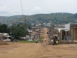
Map of Mubende, Uganda
Location
Mubende District is bordered by Kyankwanzi District to the north, Kiboga District to the northeast and Mityana District to the east. Gomba District and Sembabule District lie to the south, Kyegegwa District to the southwest and Kibaale District to the northwest of Mubende District. Mubende, the district headquarters, is located approximately 172 kilometres (107 mi), by road, west of Kampala, the capital of Uganda, and the largest city in that country. The coordinates of Mubende District are:00 36N, 31 24E.
Overview
The district covers an area of approximately 4,620 square kilometres (1,780 sq mi). It has fifteen lower local governments which include:
Population
The 1991 population census estimated the district population at about 277,500. In 2002 the national census estimated the population of the district to be about 423,450 people of whom (50.3%) were males and (49.7%) were female, with an annual population growth rate of 3.6%. It is estimated that in 2012, the population of the district was about 610,600.
Economic activity
The major economic activity in Mubende District is agriculture with emphasis on food crops like:
Cash crops grown in the district include: