
Population 1,899 (2011 census) Mean min temp Annual rainfall | Postcode(s) 4718 Mean max temp Mean min temp Postal code 4718 Local time Monday 11:08 PM | |
 | ||
Location 589 km (366 mi) from Brisbane171 km (106 mi) from Rockhampton Weather 25°C, Wind E at 13 km/h, 84% Humidity | ||
Moura is a small town and locality in the Shire of Banana in Central Queensland, Australia. It services the surrounding coal mining and rural activities. It is situated approximately 65 kilometres (40 mi) west of Biloela on the Dawson Highway, 186 kilometres (116 mi) west of the port city of Gladstone, and 171 kilometres (106 mi) south west of Rockhampton. At the 2011census, Moura had a population of 1,899 people.
Contents
- Map of Moura QLD 4718 Australia
- Economy
- History
- Mining disasters
- Climate
- Education
- 150th meridian
- APEX Park river
- Museum
- Muddy Water Classic
- Campdrafting
- Coal and Country Festival
- Facilities
- Town Twinning
- References
Map of Moura QLD 4718, Australia
Economy
A number of industries are represented in the local economy. Chief amongst these is coal mining. The name of the local coal mine changes each time it's sold - currently Dawson Mine - owned and operated by Anglo Coal. Only open-cut mining has been used since 1994. Beef, cotton and cereals are other major industries of the area.
History
In 1854 Charles Marshall named his leased pastoral selection Moura. There are two theories regarding the origin of the name. One is that it is named after Moura in Portugal where he served in the British Army during the Peninsular Wars. The other is that it is an Aboriginal word meaning native camp dog.
The Moura property was developed into a homestead in 1880 by Edward Homer. The town was first established in 1936 as a farming centre near the existing Moura Station.
The Moura Post Office opened in late 1939.
Moura Provisional School was opened on 10 September 1940. It became Moura State School on 1 January 1948. In 1965 a secondary department was attached to the school. By 1975, there were sufficient secondary students to warrant a formal high school and so Moura State High School was opened on 25 January 1976 with 263 pupils.
Mining disasters
There have been three mining disasters that have occurred near Moura:
After 1994, underground mining ceased and the area was operated as an open-cut coal mine.
Climate
Average yearly Rainfall: 732mm, raining an average of 63 days per year. The average summer temperature is 32 degrees Celsius (with temperatures in excess of 36 degrees Celsius a common occurrence during Dec-Jan). The average winter temperature is 22 degrees Celsius.
Education
Moura State School is a government primary school (P-6), while Moura State High School is a government secondary school (7-12). Both are located in Gillespie Street.
150th meridian
The 150th meridian east, located just outside Moura, is a very popular among tourists as well as local residents to have their picture taken in the exact path of the longitude line. Rocks with drill holes have been lined up to represent the exact angle and location of longitude line.
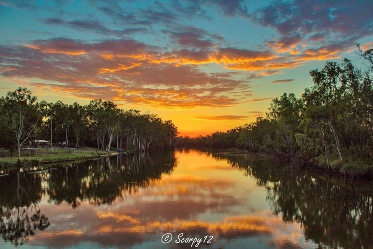
APEX Park (river)
The APEX park is situated next to the Dawson River which is located 7 kilometres (4.3 mi) west on the Dawson highway. The APEX park has free camping grounds with facilities such as hot showers, a traditional wood barbecue, toilets and lawn for the afternoon picnic. It also has a public boat ramp.
Museum
The Moura Museum and Information Centre is located at 33 Gillespie Street. The museum presents Moura's agricultural and industrial history. A set of Japanese collectables provided by the Misui Mining Company are on display.
Muddy Water Classic
Moura Muddy water classic is a fishing competition held annually on the 3rd weekend in February at the APEX park on the Dawson River. It brings many people from the surrounding areas for the local fishing competition.
Campdrafting
Moura hosts an annual campdraft in July.
Coal and Country Festival
Coal and Country festival held every year in the third week of August every year for seven days. The festival holds events like coal shovelling and a professional rodeo.
Facilities
The Banana Shire Council has an administrative office in Gillespie Street.
The town also has many shops, including banks, post office, video store, grocery store, newsagent, beauticians, hairdressers, butcher, service station, electrical, furniture and hardware store and many more. Moura also has numerous sporting clubs (golf, bowls, squash, football) as well as eateries and restaurants. There is also a RSL and Memorial (now closed) club for socialising.