
Elevation 765 m | Parent range Judean Range Judaean Mountains | |
 | ||
Similar | ||
A visit at david s tomb king david mount zion jerusalem israel
Mount Zion (Hebrew: הַר צִיוֹן, Har Tsiyyon; Arabic: جبل صهيون, Jabel Sahyoun) is a hill in Jerusalem just outside the walls of the Old City. The term Mount Zion has been used in the Hebrew Bible first for the City of David (2 Samuel 5:7, 1 Chronicles 11:5; 1 Kings 8:1, 2 Chronicles 5:2) and later for the Temple Mount, but its meaning has shifted and it is now used as the name of ancient Jerusalem's so-called Western Hill. In a wider sense, the term is also used for the entire Land of Israel.
Contents
- A visit at david s tomb king david mount zion jerusalem israel
- Map of Mt Zion Jerusalem
- Mount zion to jaffa gate audio walking tour of the old city of jerusalem
- Etymology
- The three different locations
- Lower Eastern Hill City of David
- Upper Eastern Hill Temple Mount
- Western Hill todays Mount Zion
- History since the Late Roman period
- Landmarks
- Archaeology
- References
Map of Mt Zion, Jerusalem
Mount zion to jaffa gate audio walking tour of the old city of jerusalem
Etymology
The etymology of the word Zion is uncertain. Mentioned in the Bible in the Book of Samuel (2 Samuel 5:7) as the name of the Jebusite fortress conquered by King David, its origin likely predates the Israelites. If Semitic, it may be associated with the Hebrew root ''ṣiyyôn ("castle") or the Arabic root ṣiyya ("dry land") or the Arabic šanā ("protect" or "citadel"). It might also be related to the Arabic root ṣahî ("ascend to the top") or ṣuhhay ("tower" or "the top of the mountain"). A non-Semitic relationship to the Hurrian word šeya ("river" or "brook") has also been suggested.
Sahyun (Arabic: صهيون, Ṣahyūn or Ṣihyūn) is the word for Zion in Arabic and Syriac. A valley called Wâdi Sahyûn (wadi being the Arabic for "valley") seemingly preserves the name and is located approximately one and three-quarter miles (2.8 km) from the Old City of Jerusalem's Jaffa Gate.
The phrase Har Tzion, lit. "Mount Zion", appears nine times in the Tanakh. It is spelled with a Tzadi and not Zayin.
The three different locations
The name Mount Zion referred successively to three locations, as Jerusalemites preserved the time-honoured name, but shifted the location they venerated as the focal point of biblical Jerusalem to the site considered most appropriate in their own time.
Lower Eastern Hill (City of David)
At first, Mount Zion was the name given to the Jebusite fortified city on the lower part of ancient Jerusalem's Eastern Hill, also known as the City of David.
According to the Book of Samuel, Mount Zion was the site of the Jebusite fortress called the "stronghold of Zion" that was conquered by King David, then renamed and partially rebuilt by him as the "City of David", where he erected his palace.
Upper Eastern Hill (Temple Mount)
Once the First Temple was erected at the top of the Eastern Hill, the name "Mount Zion" migrated there too.
After the conquest of the Jebusite city, its build-up area expanded northward towards the uppermost part of the same, Eastern Hill. This highest part became the site of Solomon's Temple.
The identification of the pre-Israelite (Jebusite) and Israelite towns on the Eastern Hill is based on the existence of only one perennial water source in the area, the Gihon Spring, and on archaeological excavations revealing sections of the Bronze Age and Iron Age city walls and water systems.
The "Mount Zion" mentioned in the later parts of the Book of Isaiah (Isaiah 60:14), in the Book of Psalms, and the First Book of Maccabees (c. 2nd century BCE) seems to refer to the top of the hill, generally known as the Temple Mount.
Western Hill (today's Mount Zion)
The last shift of the name Mount Zion was to the Western Hill, which is more dominant than the Eastern Hill and seemed to first-century CE Jerusalemites the worthier location for the by-then lost palace of King David. The Western Hill is what today is called Mount Zion.
In the second half of the First Temple period, the city expanded westward and its defensive walls were extended to include the entire Western Hill behind them. Nebuchadnezzar II destroyed the city almost completely around 586 BCE, severing the continuity of historical memory. A long period of rebuilding followed, ending with Jerusalem's second total destruction at the hands of the Romans in 70 CE. Josephus, the first-century CE historian who knew the city as it was before this second catastrophic event, identified Mount Zion as being the Western Hill, separated from the lower, Eastern Hill, by what he calls the "Tyropoeon Valley". It must however be said that Josephus never used the name "Mount Zion" in any of his writings, but described the "Citadel" of king David as being situated on the higher and longer hill, thus pointing at the Western Hill as what the Bible calls Mount Zion.
History since the Late Roman period
At the end of the Roman period, a synagogue was built at the entrance of the structure known as David's Tomb, probably based on the belief that David brought the Ark of the Covenant here from Beit Shemesh and Kiryat Ye'arim before the construction of the Temple.
During the 1948 war, Mount Zion was conquered by the Harel Brigade on May 18, 1948 and became the only part of the Old City to stay in Israeli hands until the armistice. At first it was linked to the Jewish neighborhood of Yemin Moshe across the Valley of Hinnom via a narrow tunnel, but eventually an alternative was needed to evacuate the wounded and transport supplies to soldiers on Mt. Zion. A cable car capable of carrying a load of 250 kilos was designed for this purpose. The cable car was only used at night and lowered into the valley during the day to escape detection; it is still in place at what is now the Mount Zion Hotel. The ride from the Israeli position at the St. John Eye Hospital to Mount Zion took two minutes.
Between 1948 and 1967, when the Old City was under Jordanian occupation, Israelis were forbidden access to the Jewish holy places. Mount Zion was a designated no-man's land between Israel and Jordan. Mount Zion was the closest accessible site to the ancient Jewish Temple. Until East Jerusalem was captured by Israel in the Six-Day War, Israelis would climb to the rooftop of David's Tomb to pray. The winding road leading up to Mount Zion is known as Pope's Way (Derekh Ha'apifyor). It was paved in honor of the historic visit to Jerusalem of Pope Paul VI in 1964.
Landmarks
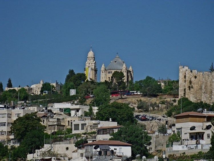
Important sites on Mount Zion are Dormition Abbey, King David's Tomb and the Room of the Last Supper. Most historians and archeologists today do not regard "David's Tomb" there to be the actual burial place of King David. The Chamber of the Holocaust (Martef HaShoah), the precursor of Yad Vashem, is also located on Mount Zion. Another place of interest is the Catholic cemetery where Oskar Schindler, a Righteous Gentile who saved the lives of 1,200 Jews in the Holocaust, is buried. Notable burials in the Protestant cemetery on Mt. Zion include the architect Conrad Schick.
Archaeology
In 1874, an Englishman, Henry Maudsley, discovered a large segment of rock scarp and numerous ancient dressed stones on Mount Zion that were believed to be the base of Josephus's First Wall. Several of these stones were used to construct a retaining wall outside the main gate of the Bishop Gobat school (later known as the American Institute of Holy Land Studies and Jerusalem University College).