
Isolation 33.0 mi (53.1 km) First ascent 13 September 1874 Parent range San Miguel Mountains | Elevation 4,344 m Prominence 1,227 m | |
 | ||
Listing North America highest peaks 43rdUS highest major peaks 29thColorado highest major peaks 14thColorado fourteeners 16thColorado county high points 15th Topo map USGS 7.5' topographic mapMount Wilson, Colorado Easiest route North Face (hike/snow climb/scramble) First ascenders A. D. Wilson, Franklin Rhoda, Ferdinand Vandeveer Hayden Similar El Diente Peak, Wilson Peak, Mount Eolus, Windom Peak, San Luis Peak | ||
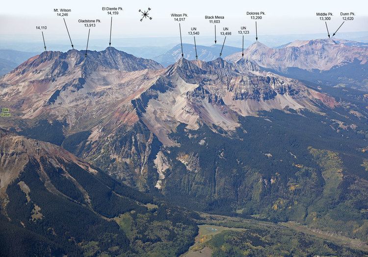
Mount Wilson is the highest summit of the San Miguel Mountains range of the Rocky Mountains of North America. The prominent 14,252-foot (4,344 m) fourteener is located in the Lizard Head Wilderness of San Juan National Forest, 10.6 miles (17.1 km) north by east (bearing 12°) of the Town of Rico in Dolores County, Colorado, United States. Mount Wilson should not to be confused with the lower Wilson Peak nearby.
Contents
- Map of Mt Wilson Colorado 81323 USA
- ClimbingEdit
- Geology and historyEdit
- Glaciers and permafrostEdit
- Historical namesEdit
- References
Map of Mt Wilson, Colorado 81323, USA
The peak was named for A.D. Wilson, a topographer with the Hayden Survey. He was in the first ascent party, which climbed the peak on September 13, 1874, via the south ridge (a difficult route, not often climbed today).
ClimbingEdit
Mount Wilson is ranked among the top ten hardest of the Colorado fourteeners to climb. The standard climbing route ascends the North Face from Navajo Basin. Some permanent snowfields exist high in the basin (sometimes termed "Navajo Glacier") and the climb usually involves snow travel, with ice axe and crampons recommended. Scrambling on rock then leads to the summit.
A popular, though long, outing for expert climbers is the mile-long ridge connecting Mount Wilson to El Diente Peak. The ridge is sharp and rocky, and requires difficult scrambling and often a small amount of rappelling.
Geology and historyEdit
Mount Wilson, and the rest of the San Miguel Mountains, are made up of a large, irregular tertiary igneous intrusion.
The Mount Wilson region became the site of intense mining activity, particularly for silver, in the early 1880s. The most famous of these mines was the Silver Pick Mine, which gave its name to Silver Pick Basin, just north of Navajo Basin.
Glaciers and permafrostEdit
Mount Wilson contains four small glaciers on its summit, these being the southernmost modern glaciers in the Rocky Mountains and indeed the most southerly in the contiguous US outside the Sierra Nevada in California. These descend to 3,887 metres (12,753 ft). None of the glaciers have ever been named, and it has never been investigated whether they are presently active. At least nine rock glaciers, composed of alpine permafrost, exist on the northern slope of the mountain, extending down to around 10,000 feet (3,050 m), although the lower limit of permafrost is more typically around 11,500 feet (3,500 m).
During the Pleistocene glaciers were much more extensive than today, covering the whole summit plateau In glaciations previous to the Wisconsinian, it is generally thought that summit ice caps were even more extensive and joined to form the “San Miguel Glacier” with icecaps in the San Juan Mountains.