
Isolation 0.75 mi (1.21 km) Parent range San Miguel Mountains Prominence 73 m | Elevation 4,316 m | |
 | ||
Topo map USGS 7.5' topographic mapDolores Peak, Colorado Easiest route Difficult scramble class 3 on loose rock Similar Mount Wilson, Wilson Peak, Mount Eolus, Gladstone Peak, San Luis Peak | ||
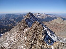
El Diente Peak is a high summit in the San Miguel Mountains range of the Rocky Mountains of North America. The 14,165-foot (4,317 m) peak is located in the Lizard Head Wilderness of San Juan National Forest, 10.5 miles (16.9 km) north by east (bearing 8°) of the Town of Rico in Dolores County, Colorado, United States. "El Diente" is Spanish for "The Tooth", a reference to the shape of the peak.
Contents
Map of El Diente Peak, Colorado 81323, USA
ClimbingEdit
The topographic prominence of El Diente Peak is only 239 feet (73 m), so by a strict 300-foot (91 m) cutoff rule it would not be counted as a separate peak from its higher neighbor Mount Wilson. However the 3/4 mile (1.2 km) connecting ridge is a significant climbing challenge (Class 4/5), making El Diente more independent than its prominence would indicate. Hence it is often regarded as a full-fledged fourteener.
El Diente is one of the more dramatic peaks in Colorado in terms of local relief and steepness. As a result, it is one of the most challenging climbs among Colorado's fourteeners. All routes involve at least class 3 scrambling on loose talus, and poor route-finding can expose the climber to more difficult and dangerous terrain.