
Elevation 777 m Easiest route Mount Verstovia Trail | Prominence 91 m | |
 | ||
Similar Mount Arrowhead, Mount Edgecumbe, Gastineau Peak, Mount Ripinski, Mount Bassie | ||
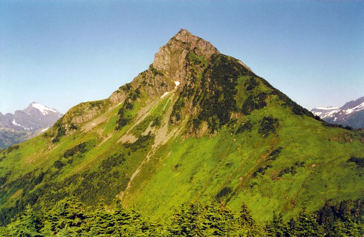
Mount verstovia and mount arrowhead hike near sitka alaska
The prominent peak of Mount Verstovia is located just 2.6 miles east of the center of Sitka, Alaska, on Baranof Island, Alexander Archipelago. The 3,354 foot summit rises steeply from the nearby pacific ocean, with its lower flanks cloaked in temperate old growth rain forests and its upper regions, above 2,400 feet, being above treeline and providing excellent vistas of Sitka and the surrounding mountain and ocean environments.
Contents
- Mount verstovia and mount arrowhead hike near sitka alaska
- Map of Mt Verstovia Sitka AK 99835 USA
- Hiker rescued from mount verstovia
- Access and recreation
- References
Map of Mt Verstovia, Sitka, AK 99835, USA
This peak was first named "Gora Verstovaya" in 1809 by the navigator Ivan Vasiliev[1]. Gora translates to mount in Russian and verst refers to a unit of measurement equaling 0.6629 miles (or 3,500 feet) which closely resembles the actual height of Mt. Verstovia.
A significant sub peak of Mount Verstovia lies just 0.5 miles to the west of the main summit. This 2,550 foot "hump" was reported in 1869 by G Davidson, USC&GS, to be named Cross Mountain. It is said to have acquired that name as the Russians erected a cross there[2]. This sub peak is now locally referred to as "Picnic Rock" although it bears no name on USGS maps. It should also be noted, in hopes of avoiding confusion, that modern USGS maps now name an entirely different peak some 8 miles to the southeast as "Cross Mountain"{
Hiker rescued from mount verstovia
Access and recreation
Mount Verstovia is accessible by a well-maintained public trail that, departs from Jamestown Bay and after 1.8 miles of switchbacks, arrives at the top of "Picnic Rock" (USGS 2,550'). One may continue on to Mount Verstovia's summit by following the unmaintained trail approximately 0.8 miles to the east. This unmaintained trail includes some steep scrambles and requires basic alpine skills and judgement.
Snowboarding, skiing, and other winter sports are very popular in the bowl nestled between "Picnic Rock" and Mount Verstovia. The trail is marked with reflective signs on tree trunks to help snow aficionados find their way up in snowy conditions.