
Topo map USGS Sitka Easiest route Scramble Prominence 457 m | First ascent Unknown Elevation 1,158 m | |
 | ||
Location Baranof Island, Sitka City and Borough, Alaska Similar Mount Verstovia, Gastineau Peak, Mount Bassie, Mount Ripinski, Devils Paw | ||
Mount verstovia and mount arrowhead hike near sitka alaska
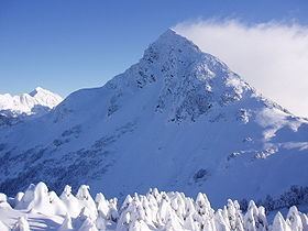
Mount Arrowhead or, as it is more commonly referred to, simply Arrowhead, is a mountain just east of Sitka, Alaska on Baranof Island that is, according to USGS maps, actually named Mount Verstovia.
Contents
- Mount verstovia and mount arrowhead hike near sitka alaska
- Map of Arrowhead Peak Sitka AK 99835 USA
- Name background
- Access
- References
Map of Arrowhead Peak, Sitka, AK 99835, USA
Name background
Arrowhead, like Mount Verstovia, is almost always incorrectly referred to in regular conversation. What is colloquially called Arrowhead is really Mount Verstovia and the real Mount Arrowhead lies about a mile and a half to the east on the same ridge out of sight from downtown Sitka. The naming confusion is understandable however, because the real Mount Verstovia (or colloquial Arrowhead) bears an uncanny resemblance to its namesake.
Access
Almost all hikes up Arrowhead begin up the Mount Verstovia trail and continue up Arrowhead's western ridge on an informal trail and then cuts behind to the southern face and continues as a scamble up a ravine for the last two or three hundred feet. It is also possible to access from the eastern ridge although it is easier (and safer) to ascend before descending. Because of this, the primary alternate route is cutting underneath the cliffy northwestern face and meeting up with the eastern ridge and the ascending.