
Pronunciation [tandʑoːsaɴ] Parent range Tanjō Mountains | Elevation 514 m | |
 | ||
Similar Mount Taishaku, Mount Rokkō, Mt Taishaku, Mesuokayama, Okkosan | ||
Mount Tanjō (丹生山, Tanjō-san) is a 514 m (1,686 ft) mountain in the Tanjō Mountains, located in Sakamoto, Yamada, Kita-ku, Kobe, Hyōgo, Japan.
Contents
- Map of Mount TanjC58D Yamadacho Sakamoto Kita Ward Kobe HyC58Dgo 651 1261 Japan
- Outline and History
- Access
- References
Map of Mount Tanj%C5%8D, Yamadacho Sakamoto, Kita Ward, Kobe, Hy%C5%8Dgo 651-1261, Japan
Outline and History
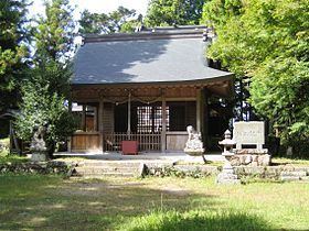
Mount Tanjō is not the tallest mountain of Tanjō Mountains, but it is a symbol of the mountain range. In the middle of the mountain, there was a Buddhist temple Myōyō-ji which was said to be established by Donan-Gyoja, a prince of King Seong of Baekje. Today's Tanjō Shrine was is believed to be part of the original temple. Mount Tanjō is also believed to have been old source of mercury, because the name Tanjō, originally means Nyu, mercury. Tanjō Shrine is a place to enshrine a goddess of mercury.
Access
References
Mount Tanjō Wikipedia(Text) CC BY-SA