
Pronunciation Japanese: [ɽokːoːsaɴ] Parent range Rokkō Mountains Elevation 932 m | Mountain type Fault-block | |
 | ||
Similar Mount Maya, Mount Nagamine, Mount Tanjō, Futatabisan, Mount Kongō | ||
Mount Rokkō (六甲山, Rokkō-san) is the name of a range of mountains in southeastern Hyōgo Prefecture, Japan.
Contents
- Map of Mount RokkC58D Motoyamachomori Higashinada Ward Kobe HyC58Dgo 658 0000 Japan
- Outline
- History
- Points of interest
- Trivia
- Access
- References
Map of Mount Rokk%C5%8D, Motoyamachomori, Higashinada Ward, Kobe, Hy%C5%8Dgo 658-0000, Japan
Outline
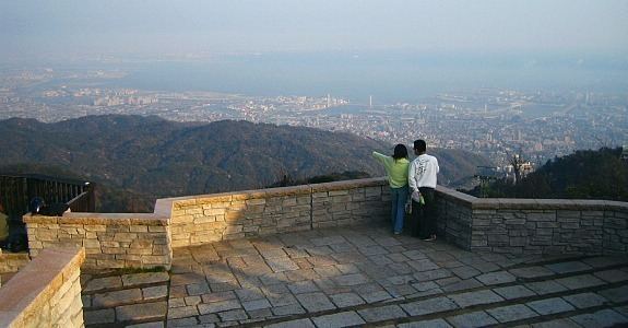
There is no single mountain or peak called "Rokkō," although the highest peak of the mountains is called Rokkōsan-Saikōhō (六甲山最高峰), (literally, the highest peak of the Rokkō Mountains) and the area to the south is known as the Rokkō area. The mountains run approximately east-west from Sumaura Kōen Park in western Kobe to Takarazuka, and the length of the range is about 56 km. The highest point is 931m. It also includes Mount Maya, Mount Kabutoyama, Mount Iwahara and Mount Iwakura.
Today, the Rokkō mountain area is a centerpiece of a popular sightseeing and hiking area for people in the metropolitan Kansai region. Mt. Rokkō is a symbol of Kobe as well as Osaka.
History
Arthur Hasketh Groom opened the first golf course in Japan, Kobe Golf Club, on Mt. Rokko in 1903.
Points of interest
Trivia
For many years, lenses made by the Minolta Camera Company were designated as "Rokkor", named after the mountains near Osaka, where the company was headquartered.