
Topo map USGS La Jolla OE W Prominence 144 m | Elevation 251 m | |
 | ||
Similar Cowles Mountain, Cuyamaca Peak, Palomar Mountain, El Cajon Mountain, San Miguel Mountain | ||
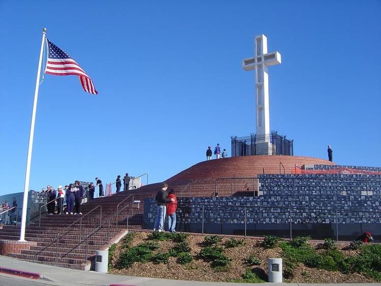
Mount Soledad is a prominent landmark in the city of San Diego, California, United States. The mountaintop is the site of the Mount Soledad cross, the subject of a 25-year controversy over the involvement of religion in government, which concluded in 2016.
Contents
- Map of Soledad Mountain San Diego CA 92037 USA
- GeographyEdit
- Land eventsEdit
- Legend of Munchkin landEdit
- Last home of Dr SeussEdit
- In literatureEdit
- CyclingEdit
- Mount Soledad crossEdit
- References
Map of Soledad Mountain, San Diego, CA 92037, USA
GeographyEdit
The 822-foot (251 m) tall hill lies between Interstate 5 to the east and the Pacific Ocean to the west. It is mostly within the community of La Jolla where the northern and eastern slopes form a sharp escarpment along the Rose Canyon fault. The community of Pacific Beach is on the gentler southern slope. There are several radio and television transmitters located on the summit including KFMB-TV and KGTV, the CBS and ABC affiliates respectively. Commercial aircraft approaching San Diego from the direction of Los Angeles often use Mount Soledad as their point to start the downwind leg of their approach to San Diego International Airport.
Land eventsEdit
On October 3, 2007, one home on Soledad Mountain Road and one of the main roads up the mountain was destroyed by a major landslide. Five houses were damaged, and over 20 others were evacuated. The city of San Diego had noticed water and gas main leaks since July, and cracks in the pavement since August, 2007.
Legend of Munchkin landEdit
There is an urban legend that in the 1930s, a group of little people who appeared in Hollywood films such as The Wizard of Oz, came to San Diego where they built miniature houses on Mount Soledad.
The legend gained traction due to the fact several houses were built on steep slopes overlooking the Pacific. As passing observers looked down, the perspective made doors and other features appear smaller than normal. Most of the supposed "Munchkin Houses" have been remodeled and the effect is no longer present.
Last home of Dr. SeussEdit
Mount Soledad is the location of the last home lived in by Dr. Seuss. His widow, Audrey Geisel, still resides atop Mt. Soledad in a lavish home, which includes an observation tower referred to as the Seuss house by the locals.
In literatureEdit
Mount Soledad figures in a major location for San Diego-born writer Adam Gnade's 2011 novella, Hey Hey Lonesome.
CyclingEdit
Because of the variety of long steady climbs, light traffic on most routes, and great views, Mount Soledad is a popular cycling destination and area. There are numerous routes ranging from the relatively gradual, 3.5-mile (5.6 km) mile climb up Soledad Mountain Road on the southern slopes to the very steep and short, 1.25-mile (2.0 km), Hidden Valley Road to Via Capri route on the north side.
The routes up to the top of Mount Soledad going clockwise starting in Pacific Beach, are (note: the footnotes are links to Google maps showing the routes):
- Soledad Mountain Road - From Garnet Ave up Soledad Mountain Road to La Jolla Scenic Drive South.
- Variation (Pacifica) - From Pico Street at Garnet Ave: Pico Street, Pacifica Drive (steep), Amity Street, Middleton Road, Middleton Way, Soledad Rancho Road, Soledad Mountain Road, La Jolla Scenic Drive South.
- Variation (Beryl Way and Pendleton St.) - Soon after starting up Soledad Mountain Rd, take Beryl Way, left on Beryl St., right on Quincy, right on Wilbur, left on Loring, right on Pendleton, left on Amity to join the Pacifica variation route.
- Soledad Road - Lamont Street, which becomes Soledad Road, to Soledad Mountain Road and La Jolla Scenic Drive South.
- Variation (Alta La Jolla Drive) - While going up Soledad Road, turn left at Alta La Jolla Drive, then right on Cardeno Drive and up to the top via La Jolla Scenic Drive.
- Cardeno Drive - Fanuel Street, which becomes Cardeno Drive, to La Jolla Scenic Drive South.
- Variation (Castle Hills Drive) - From Foothill Blvd. at Vickie Drive head up Vickie Drive, then left on Castle Hills Drive, and Calle Vaquero to Cardeno Drive.
- Candlelight-Rutgers - From Turquoise St at Cass St, take Cass St up, left on Van Nuys, right on Candlelight Dr, Vista Claridad, Rutgers Rd, to La Jolla Scenic Drive South.
- La Jolla Mesa - Mission Boulevard, which becomes La Jolla Mesa Drive, to La Jolla Scenic Drive South.
- La Jolla Rancho - Forward Street, Linda Rosa Ave, La Jolla Corona Drive, La Jolla Rancho Road, La Jolla Scenic Drive.
- Muirlands Vista - Nautilus Street, Muirlands Vista Way, Muirlands Drive, La Cumbre Drive, El Camino Teatro, La Jolla Scenic Drive South.
- Muirlands - West Muirlands Drive, briefly left on Nautilus, then Muirlands Drive, El Camino Teatro and La Jolla Scenic Drive South.
- Nautilus - Nautilus Street at Neptune Place to La Jolla Scenic Drive South.
- Valverde - Nautilus Street, Via Valverde, Caminito Valverde, Caminito Bassano West, Upper Hillside Drive, Via Casa Alta (steep grade), La Jolla Scenic Drive South.
- Upper Hillside - Exchange Place, Country Club Drive, Romero Drive, Brodiaea Way, Encilia Drive, Upper Hillside Drive (requires walk through side pedestrian gates to get around a short section of private road with locked gates across the road at each end), Via Casa Alta, La Jolla Scenic Drive South.
- Hillside - Hillside Drive at Torrey Pines Road to Via Siena and up Via Capri (very steep).
- Variation (paved path): Where Hillside becomes Via Siena, turn right to continue along the remaining short dead-end section of Hillside, where it becomes a paved path. At the end of the path it is easy to connect to Via Capri near the top.
- Variation (Soledad Ave) - Exchange Place, Soledad Ave, to Hillside Drive....
- Variation (historic bridge [1] detour) - Exchange Place, Soledad Ave, Al Bahr Drive, Crespo Street, Castellana Road to Hillside Drive...
- Via Capri - Hidden Valley Road to Via Capri - very steep in sections.
Mount Soledad crossEdit
Mount Soledad is topped by a large concrete Christian cross, first built in 1913, and since rebuilt twice. The third and current version was dedicated in 1954 as the Mount Soledad Easter Cross; the word "Easter" was dropped in the 1980s. After the cross was challenged in court during the late 1980s, it was designated a Korean War memorial. It became the center of a controversy, known around the world, over the display of religious symbols on government property.
In December 2008, a local San Diego painting contractor donated time and material to restore the cross.
It was ruled unconstitutional by the United States Court of Appeals for the Ninth Circuit in January 2011.
On June 25, 2012, the United States Supreme Court denied certiorari, allowing the order of the Ninth Circuit to stand.
In July 2015, a group called the Mt. Soledad Memorial Association reported that it had bought the half-acre of land under the cross from the Department of Defense for $1.4 million. On September 7, 2016 the U.S. Court of Appeals for the Ninth Circuit issued a one-page ruling, ordering dismissal of the case and an end to all current appeals, stating that the case was now moot because the cross was no longer on government land. Both sides agreed that this decision puts a final end to the case.