
Last eruption 1970 | Elevation 862 m | |
 | ||
Similar Inielika, Iliwerung, Iliboleng, Inierie, Ilimuda | ||
Mount sirung volcano eruption 2012
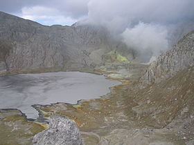
Mount Sirung (Indonesian: Gunung Sirung) is an active volcano complex volcano located on Pantar Island in the Alor archipelago of the eastern Indonesian province of Nusa Tenggara Timor. The crater rim can be reached by an easy hike from the village of Kakamauta. Inside the crater is a large sulphurous crater lake and several active steam vents. The last major eruption occurred 1970, and regular gas and clastic eruptions have occurred since 2004. A small eruption beginning May 12, 2012 triggered an evacuation of an area within a 1.5 km radius of the caldera.
Contents
- Mount sirung volcano eruption 2012
- Map of Mount Sirung Mauta Central Pantar Alor Regency East Nusa Tenggara Indonesia
- References
Map of Mount Sirung, Mauta, Central Pantar, Alor Regency, East Nusa Tenggara, Indonesia
References
Mount Sirung Wikipedia(Text) CC BY-SA