
Elevation 2,932 m | ||
 | ||
Topo map Geospatial Information Authority 25000:1 白馬岳50000:1 白馬岳 Similar Mt Goryu, Mt Karamatsu, Shakushidake, Mt Korenge, Mt Kashima‑Yarigatake | ||
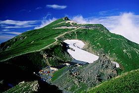
mt shirouma dake main ridge and skiing daisekkei
Mt. Shirouma (白馬岳, Shirouma-dake) is a peak in the Hida Mountains range of the Japanese Alps, located in Nagano Prefecture and Toyama Prefecture, central Honshu, Japan.
Contents
- mt shirouma dake main ridge and skiing daisekkei
- Map of Mount Shirouma Yamazaki Asahi Shimoniikawa District Toyama Prefecture 938 0162 Japan
- Small hut at mount shirouma japan
- Geography
- References
Map of Mount Shirouma, Yamazaki, Asahi, Shimoniikawa District, Toyama Prefecture 938-0162, Japan
Small hut at mount shirouma japan
Geography
Mount Shirouma is the 26th-tallest mountain in Japan. At 2,932 metres (9,619 ft), it is the highest peak in the Hakuba section of the Hida Mountains, and one of the top "to climb" peaks for Japanese hikers. It is also one of the few peaks in Japan with year-round snow fields (Firn), in the Shirouma Dai Sekkei, or Shirouma deep-snow gorge (白馬大雪渓).
It is located within the Chūbu-Sangaku National Park. Mount Shirouma is one of the landmark 100 Famous Japanese Mountains.
Alpine plants are also abundant on Shirouma in the summer.
References
Mount Shirouma Wikipedia(Text) CC BY-SA