
Topo map NTS 104F/08 Prominence 2,430 m | Elevation 3,090 m | |
 | ||
Listing North America prominent peak 40thNorth America isolated peaks 63rdCanada highest major peaks 61stCanada most prominent peak 14thCanada most isolated peaks 20th Similar Mount Queen Bess, Skihist Mountain, Mount Ulysses, Mount Sir Wilfrid Laurier, Mount Odin | ||
Wolf house live mount ratz something involving a deth of the hawk di covery
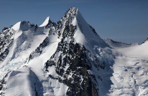
Mount Ratz is a mountain located just west of the Stikine River, about 5 km (3 mi) east of the British Columbia-Alaska border. It is the highest peak in the Stikine Icecap and of the Boundary Ranges which in turn form part of the Coast Mountains. It is an extremely high-prominence summit, with a difference in elevation with its "key col" at Hyland Ranch Pass of 2,430 m (7,972 ft). Thus making it one of Canada's Ultra peaks.
Contents
- Wolf house live mount ratz something involving a deth of the hawk di covery
- Map of Mount Ratz Kitimat Stikine D BC Canada
- Mount ratz nocturnal emissions i
- References
Map of Mount Ratz, Kitimat-Stikine D, BC, Canada
Mount Ratz is named for William F. Ratz, Dominion Land Surveyor and engineer-in-charge of surveying the Taku, Whiting and Stikine Rivers, who died on February 6, 1909.
Mount ratz nocturnal emissions i
References
Mount Ratz Wikipedia(Text) CC BY-SA