
First ascent Prior to 1518 | Elevation 1,841 m | |
 | ||
Topo map Geographical Survey Institute, 25000:1 白山, 50000:1 白山 Similar Mt Ogasa, Sanpoiwadake, Mt Daimon, Naradake, Mt Kongodo | ||
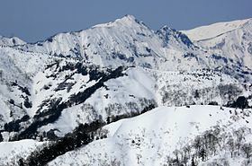
Mount Oizuru (笈ヶ岳, Oizuru-ga-take) is located on the borders of Gifu, Ishikawa and Toyama prefectures in Japan. It is in the northern area of Hakusan National Park and is part of the Ryōhaku Mountains.
Contents
Map of Mt. Oizurugatake, Chugu, Hakusan, Ishikawa Prefecture 920-2324, Japan
Geography
Mount Oizuru, at 1,841 m (6,040 ft), is the tallest mountain in the northern part of the Ryōhaku Mountains. Just north of the mountain is Mount Ōgasa (大笠山 Ōgasa-yama), which is slightly shorter at 1,821 m (5,974 ft). There are three triangulation stations on the mountain's thin peak.
History
Taichō is said to have first scaled the mountain in the early eighth century.
References
Mount Oizuru Wikipedia(Text) CC BY-SA