
Elevation 1,617 m First ascender Taichō | First ascent 718 AD | |
 | ||
Topo map Geographical Survey Institute, 25000:1 能郷白山, 50000:1 岐阜 Similar Mount Haku, Mt Arashima, Mount Kanmuri, Hanabusayama, Mount Oizuru | ||
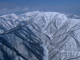
Mount Nōgōhaku (能郷白山, Nōgōhaku-san) is located on the borders of Gifu and Fukui prefectures in Japan. It is part of the Ryōhaku Mountains and serves as the drainage divide between the Pacific Ocean and the Japan Sea. There is one triangulation station at the top of the mountain.
Contents
Map of Mount N%C5%8Dg%C5%8Dhaku, Nukumi, Ono, Fukui Prefecture 912-0000, Japan
Fragaria iinumae was discovered at first in this Mountain and the name Nōgō Fragaria (ノウゴウイチゴ・能郷苺, Nōgō Ichigo) was given.
History
References
Mount Nōgōhaku Wikipedia(Text) CC BY-SA