
Prominence 1,818 m | Elevation 3,083 m | |
 | ||
Similar | ||
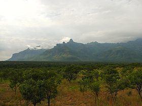
Mount Moroto, also Moroto Mountain (3,083 m or 10,115 ft), is a mountain in Uganda.
Contents
Map of Mount Moroto, Uganda
Location
The mountain is adjacent to the town of Moroto in Moroto District, Karamoja, Northern Region of Uganda. It is approximately 3 kilometres (1.9 mi), by road, east of Moroto's central business district. Mount Moroto is one of a chain of volcanoes along Uganda's international border with Kenya that begins with Mount Elgon in the south and includes Mount Kadam and Mount Morungole. The region around Mount Moroto is a forest reserve protecting a range of habitats from arid thorn savanna to dry montane forest. The coordinates of Mount Moroto are 2°31'30.0"N, 34°46'21.0"E (Latitude:2.5250; Longitude:34.7725).
Mountain climbing
The nature reserve that encloses Mount Moroto measures 483 square kilometres (119,000 acres) and contains over 220 bird species, monkeys and wild cats. Climbing trails exist and mountain guides are available.
Farming and irrigation
The natural springs on the slopes of the mountain coalesce to form springs and small rivers. The World Food Program is teaching the Karimajong people how to harvest and store that water and use it to irrigate agricultural produce for household food and for income generation.