
Prominence 55 m | Topo map USGS 7½' Stroudsburg Elevation 445 m | |
 | ||
Easiest route Appalachian National Scenic Trail (Hiking) Similar Mount Tammany, The Pinnacle, Sunrise Mountain, Hawk Mountain, Camelback Mountain | ||
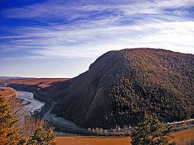
Mount Minsi forms the Pennsylvania side of the Delaware Water Gap, and is the eastern extent of the Blue Mountain. It is composed of sandstone and conglomerates of the Shawangunk Formation.
Contents
- Map of Mt Minsi Delaware Water Gap PA 18013 USA
- A hike along the appalachian trail delaware water gap to mount minsi
- HikingEdit
- ClimbingEdit
- References
Map of Mt Minsi, Delaware Water Gap, PA 18013, USA
A hike along the appalachian trail delaware water gap to mount minsi
HikingEdit
The easiest route to the summit of Minsi is by way of the Appalachian Trail, from the Lake Lenape trailhead near the town of Delaware Water Gap. The Mount Minsi fire road shares and parallels parts of the same route on the same northwest slopes. Both travel about 5 miles (8 km) round trip, and gain 1,020 feet (310 m) of elevation.
ClimbingEdit
The band of exposed metaquartzite cliffs on east face of Minsi hold a number of traditional climbing routes. The earliest of these were put up in 1975, and established routes range from 5.0 to 5.12+. Winter can offer some mixed and ice climbing as well.