
Isolation 70 kilometres (43 mi) Elevation 4,565 m Prominence 3,170 m First ascender Fritz Jäger | Listing Ultra Easiest route Hike Last eruption 1910 First ascent 1904 Mountain range Eastern Rift mountains | |
 | ||
Similar Mount Kilimanjaro, Ol Doinyo Lengai, Mount Kenya, Shira, Meru Peak | ||
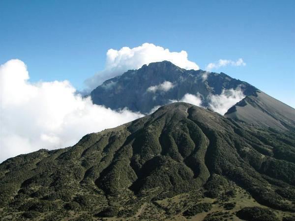
Mount Meru is a dormant stratovolcano located 70 kilometres (43 mi) west of Mount Kilimanjaro in the nation of Tanzania. At a height of 4,562.13 metres (14,968 ft), it is visible from Mt Kilimanjaro on a clear day, and is the fifth highest mountain in Africa, dependent on definition.
Contents
Map of Mt Meru, Tanzania
Mount Meru is located just north of the city of Arusha, in the Arusha Region of Tanzania. It is the second-highest mountain in Tanzania, after Mount Kilimanjaro. The Momella route - which starts at Momella gate, on the eastern side of the mountain - is used to climb Mount Meru.
Much of its bulk was lost about 8,000 years ago due to an eastward volcanic blast, similar to the 1980 eruption of Mount St. Helens in the U.S. state of Washington. Mount Meru most recently had a minor eruption in 1910. The several small cones and craters seen in the vicinity probably reflect numerous episodes of volcanic activity.
Mount Meru is the topographic centerpiece of Arusha National Park. Its fertile slopes rise above the surrounding savanna and support a forest that hosts diverse wildlife, including nearly 400 species of birds, and also monkeys and leopards.
Resting place of Noah's Ark
Some have suggested that Mount Meru was the place where Noah's Ark came to rest as the flood receded. According to this view, the old Arabic text of Genesis 8:4 identifies the resting place as "har-meni", which "refers to the mountain of Meni or Menes, another name for Mount Meru". The similarity between Har-meni and Armenia, however, led to the Christian tradition of identifying Mount Ararat, in Armenia, as the site.