
Topo map USGS Mount McLoughlin Last eruption About 30,000 years ago Prominence 1,358 m Volcanic arc Cascade Volcanoes | Mountain type Composite volcano Elevation 2,894 m | |
 | ||
Age of rock Less than 700,000 years Similar Mount Thielsen, Mount Bailey, Pelican Butte, Mount Scott, Diamond Peak | ||
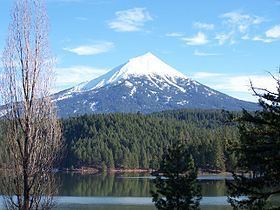
Mount McLoughlin is a steep-sided lava cone built on top of a composite volcano in the Cascade Range of southern Oregon and within the Sky Lakes Wilderness. It is one of the volcanic peaks in the Cascade Volcanic Arc. The mountain is north of Mount Shasta, south of Crater Lake, and west of Upper Klamath Lake. It was named around 1838 after John McLoughlin, a Chief Factor for the Hudson's Bay Company. Mount McLoughlin has been known by a number of different names over the years, including Mount Pitt (after the Pit River), Big Butte, M'laiksini Yaina (Klamath Indians), Malsi (Takelma Indians), Mount Shasty (although this name was applied to Mount Shasta to the south by the 1841 Wilkes Expedition), and Snowy Butte.
Contents
Map of Mt McLoughlin, Oregon 97524, USA
The Pacific Crest Trail skirts the eastern and northern sides and also accesses the only trail to the summit. On a clear day, the Sky Lakes Wilderness, Crater Lake, the Rogue Valley, and Mount Shasta are visible from the summit.
GeologyEdit
Except for a short monograph written by Arthur B. Emmons in 1886, little was known about Mount McLoughlin's geology until the 1970s. Much of what is known today comes from LeRoy Maynard of the Center for Volcanology at the University of Oregon.
The 3-cubic-mile (13 km3) volcano went through three or four stages of development and stopped growing some time before the most recent period of glaciation about 25,000 years ago.
The first known stage of the volcano's growth was explosive and built a large cinder cone from a single vent that may have reached the unusual height of 3,000 feet (910 m) and may account for one third of McLoughlin's present interior. A steep-sided pre-existing shield volcano may exist within the cinder cone, thus explaining its extreme height. Some lava is associated with this stage but is confined to the lower parts of the cinder cone. A second cone-building stage was characterized by large andesite lava flows that poured out of a summit crater and in time buried the cinder cone. The third stage of development consisted of floods of blocky andesite lava erupting from below the summit and more fluid lavas erupting from basal fissures, mostly confined to the south slope. North Squaw Tip and South Squaw Tip on McLoughlin's west flank now mark the site of the two major blocky flow vents. There were two smaller vents as well. The entire third stage is thought to have happened in the Holocene period, after the last ice age, due to a general lack of weathering and fresh appearance of the solidified lava.
During the last ice age, a large ice cap buried most of the High Cascades, with Mount McLoughlin marking the southern terminus of this structure. The ice cap was 200 to 300 feet (61 to 91 m) thick where it touched the mountain. A large ice-age glacier on the northeast side of the volcano severely eroded that part of the mountain, creating an asymmetrical cone. A cirque glacier occupied part of the depression until early in the 20th century. The volcano's crest is located south of the central vent, and its crater has long since been eroded away along with about 500 feet (150 m) of its former height.