
Topo map PCGS-2511 | Elevation 1,388 m | |
 | ||
Similar Mount Natib, Mount Samat, Mount Arayat, Laguna Caldera, Mount Samat National | ||
Mount Mariveles is a dormant volcano located in the province of Bataan in the Philippines. Mt. Mariveles and the adjacent Mount Natib comprise 80.9 percent of the total land area of the province. The mountain and adjacent cones lie opposite the city of Manila across Manila Bay, providing a beautiful setting for the sunsets seen from Manila.
Contents
- Map of Mount Mariveles Bagac Bataan Philippines
- LocationEdit
- Physical featuresEdit
- EruptionsEdit
- GeologyEdit
- ListingsEdit
- Climbing MarivelesEdit
- References
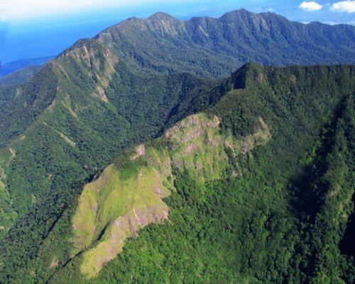
Map of Mount Mariveles, Bagac, Bataan, Philippines
LocationEdit
Mount Mariveles lies at the southern end of the Zambales Mountains in the Bataan Peninsula, west of Manila Bay. Bataan province belongs to the Central Luzon or Region III of the Philippines.
Physical featuresEdit
Mariveles is a massive stratovolcano topped with a 4-kilometre (2.5 mi) summit caldera which drains to the north. The highest peak, called Mariveles, has an elevation of 1,388 metres (4,554 ft) asl. Mounts Pantingan, Bataan, Tarak, and Vintana are the other peaks of the volcano-caldera complex, which has a base diameter of 22 kilometres (14 mi).
Mount Samat on the northern slope and Mount Limay on the eastern slope, are major, youthful-looking parasitic cones of the volcano.
Mariveles is still thermally active with the following hot springs located within the complex: Tiis Spring, Saysain Spring, and Pucot Spring.
EruptionsEdit
There are no recorded historical eruptions from Mariveles caldera. But archeologists report the last active eruption indicated by Radiocarbon dating occurring around mid-Holocene or about 2050 BCE.
GeologyEdit
Rock type is predominantly biotite, hornblende, and andesite, with dacite flows and dacitic tuffs similar to nearby Mount Natib.
Mount Mariveles is on the Western Bataan Lineament volcanic belt of Luzon, which includes Mount Pinatubo, site of the second largest eruption of the last 20th century.
ListingsEdit
The Philippine Institute of Volcanology and Seismology (PHIVOLCS), the Philippine government branch that deals with volcanology in the country, lists Mariveles as a potentially active volcano for the age of its last eruption and active thermal features.
Climbing MarivelesEdit
There are already three peaks familiar to the local mountaineering community namely: Tarak Ridge, Pantingan or Banayan Peak, and Mariveles Ridge. The rest of the peaks in the caldera are still waiting to be explored.
Tarak Ridge is the more well-known destination on Mount Mariveles with its jump-off point situated at Barangay Alas-asin, Mariveles, Bataan. Pantingan Peak (locally called Banayan Peak) can be accessed through Sitio Duhat, Saysain, Bagac, Bataan. Mariveles Ridge can be accessed through Sitio Parca, Mariveles, Bataan.