
Elevation 2,183 m | ||
 | ||
Similar Mount Gayong, Gunung Yong Belar, Mount Chamah, Mount Yong Yap, Mount Tahan | ||
Extreme hiking mount korbu gayung 2 hari 1 malam
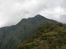
Mount Korbu (Malay: Gunung Korbu) is a mountain in Hulu Kinta, Perak, Malaysia, about 25 km from Ipoh. It is the highest peak of the Titiwangsa Mountains, the southernmost section of the Tenasserim Hills.
Contents
- Extreme hiking mount korbu gayung 2 hari 1 malam
- Map of Mount Korbu Perak Malaysia
- Mount korbu expedition malaysia gopro hero 3b
- Nearby
- References
Map of Mount Korbu, Perak, Malaysia
Mount Korbu is also the second highest mountain in Peninsular Malaysia, standing at 2,183 metres. The highest peak is Mount Tahan at 2,187 metres in the state of Pahang. A reasonable level of physical fitness is required to conquer Mount Korbu and it is not recommended for first time climbers. An average climber would need four days and three nights for a return trip. A local guide is needed to scale this mountain as the route is unmarked and climbers would get easily lost. Mount Gayong (2,173 m), fourth highest mountain in Peninsular Malaysia, can be reached in about an hour's trek from the peak of Mount Korbu.
Between 23 and 26 May 2013, 65 volunteers took part in a trail maintenance and clean-up project on Mount Korbu via the Sungai Termin Trail. It was the second such conservation project of the non-profit Adopt A Mountain (AdAM).
Mount korbu expedition malaysia gopro hero 3b
Nearby
8 km away from Mount Korbu, straddling the Perak-Kelantan border is Mount Yong Belar, Peninsular Malaysia's third tallest mountain, standing at 2,181 metres (7,156 ft) above sea level.