
Topo map NTS 82O/03 First ascent Unknown Elevation 2,240 m Province Alberta Age of rock Paleozoic | Mountain type Limestone & shale Easiest route Scramble Prominence 240 m Mountain range Canadian Rockies Parent range Canadian Rockies | |
 | ||
Similar Heart Mountain, Ha Ling Peak, Grotto Mountain, Mount Lady Macdonald, East End of Rundle | ||
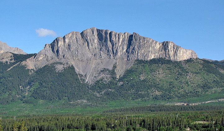
Mount John Laurie is a mountain in the Canadian Rockies, located in the province of Alberta, Canada.
Contents
Map of Mount Yamnuska, Bighorn No. 8, AB, Canada
Officially named Mount John Laurie in 1961, it is also known as Mount Laurie, or by the Nakoda name Mount Yamnuska, or simply Yamnuska. Yamnuska translates to "wall of stone." "Yamnuska" is derived from the Stoney Nakoda word "Iyamnathka" that describes steep cliffs or "the flat faced mountain."
John Lee Laurie, 1899-1959, was a founder of the Indian Association of Alberta. The mountain's 1961 renaming came at the request of the Stoney Nakoda First Nation. Laurie, an educator and political activist, served as secretary of the Indian Association of Alberta from 1944-1956, promoting the causes of Alberta native peoples.
Standing at approximately 2,240 meters above sea level, Mount John Laurie is the first mountain on the north side of the Bow River valley (Bow Valley) as it exits the mountains for the foothills and prairie of Alberta. Located close to Calgary, it is a popular "great scramble". It is also a popular rock climbing destination, with over 100 routes of all difficulty levels spread out across its face.
Mount John Laurie is the result of the McConnell Thrust Fault, which put the resistive, cliff forming Cambrian carbonate rock of the Eldon Formation on top of the much younger and weaker Cretaceous aged, clastic Belly River Formation The fault, which sits at the base of the cliff face, represents an age difference of around 450 million years.
AccessEdit
At the Highway 1X and Highway 1A (Bow Valley Trail) intersection, travel east for 2 kilometers. Turn into the signed parking lot that says "Yamnuska."