
Elevation 627 m | ||
 | ||
Similar Puriri Bay, Motuihe Island, Rotoroa Island, North Head - New Zealand, Motutapu Island | ||
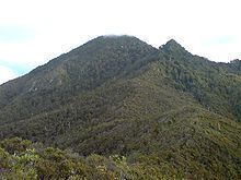
Mount Hobson (Hirakimata in Maori) is the highest mountain on Great Barrier Island, New Zealand. Located in the centre of the island, it rises 621 m (2,037 ft) above sea level.
Map of Mount Hobson, Great Barrier Island 0991, New Zealand
Various mountain tracks allow relatively easy access to the summit, with the shortest (2 hour) track leading through the famous Windy Canyon. Great views over the island, to the Coromandel Peninsula and the Poor Knights Islands are often possible from the top of the mountain. The summit area is also a breeding ground for the black petrel, and the track in this part is mostly composed of boardwalks and stairs to protect the breeding areas and prevent erosion. A number of rare and declining plants on the mainland are largely restricted (or completely restricted) to Great Barrier Island are found on Mount Hobson, these include, Pittosporum kirkii, Epacris sinclairii, Kunzea sinclairii, and also Olearia allomii.