
Prominence 38 m | Elevation 1,425 m | |
 | ||
Similar Carter Dome, Middle Carter Mountain, South Carter Mountain, Wildcat Mountain, Mount Moriah | ||
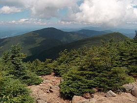
Mount Hight is a mountain located in Coos County, New Hampshire. The mountain is part of the Carter-Moriah Range of the White Mountains, which runs along the eastern-northeastern side of Pinkham Notch. Mount Hight is flanked on the north by South Carter Mountain across Zeta Pass, and on the southwest by Carter Dome.
Contents
Map of Mt Hight, Bean's Purchase, NH 03846, USA
Although well over 4,000 feet (1,200 m) in height, the Appalachian Mountain Club doesn't consider Hight a "four-thousand footer" because the col on the ridge from Carter Dome only descends 125 ft (38 m), making it a secondary summit of that peak. However, the bare summit of Mount Hight has the best views of any summit of the Carter-Moriah Range. Conversely, Carter Dome, the highest peak in the range, is wooded and has only limited views.