Topo map USGS Mount Hayes C-6 First ascent 1941 | Elevation 4,216 m Prominence 3,501 m Mountain range Alaska Range | |
 | ||
Isolation 205 kilometres (127 mi) Listing World most prominent peaks 51stNorth America highest peaks 72ndNorth America prominent peaks 10thNorth America isolated peaks 102ndUS highest major peaks 54thUS most prominent peaks 6thAlaska highest major peaks 17th Easiest route snow/ice climb (Alaska grade 2+) Similar Mount Marcus Baker, Mount Deborah, Mount Hubbard, Mount Sanford, Mount Bear | ||
Missing in alaska a ufo over mount hayes s1 e3 history
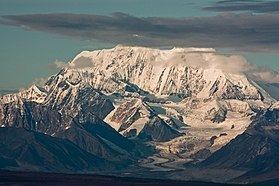
Mount Hayes is the highest mountain in the eastern Alaska Range. Despite not being a fourteener, it is one of the largest peaks in the United States in terms of rise above local terrain. For example, the Northeast Face rises 8,000 feet (2,440 m) in approximately 2 miles (3.2 km). In terms of topographic prominence, Mount Hayes is number 51 in the world.
Contents
- Missing in alaska a ufo over mount hayes s1 e3 history
- Map of Mt Hayes Alaska USA
- Mount hayes mascot mine
- References
Map of Mt Hayes, Alaska, USA
Mount Hayes was first climbed in 1941 by Bradford Washburn, Barbara Washburn, Benjamin Ferris, Sterling Hendricks, Henry Hall, and William Shand. Today's standard route is the East Ridge (Alaska Grade 2+). Mount Hayes is not frequently climbed due to its remoteness and the resulting access difficulties.
Mount hayes mascot mine
References
Mount Hayes Wikipedia(Text) CC BY-SA
