
Topo map USGS Ruby Dome Prominence 146 m | Elevation 3,418 m | |
 | ||
Similar Snow Lake Peak, Liberty Peak, Thomas Peak, Mount Fitzgerald, Ruby Dome | ||
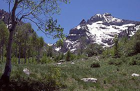
Mount Gilbert is the sixth-highest named mountain of the Ruby Mountains and the eighth-highest in Elko County, in Nevada, United States. It is the forty-third-highest mountain in the state. The peak is a spectacular part of the view from State Route 227 in Lamoille Valley, rising over 5,300 feet (1,620 m) above the valley floor at Lamoille. It rises from the head of Seitz Canyon, and is part of the west wall of Right Fork Canyon (a branch of Lamoille Canyon). The summit is a high glacial horn, located about 22 miles (35 km) southeast of the community of Elko within the Ruby Mountains Ranger District of the Humboldt-Toiyabe National Forest.
Map of Mt Gilbert, Nevada 89815, USA
References
Mount Gilbert (Nevada) Wikipedia(Text) CC BY-SA