
Topo map USGS Ruby Dome Prominence 229 m | Elevation 3,363 m | |
 | ||
Easiest route From Liberty Pass, Class 2 scramble west along the ridgeline Similar Snow Lake Peak, Thomas Peak, Mount Fitzgerald, Mount Gilbert, Verdi Peak | ||
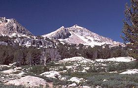
Liberty Peak is the name given to the officially unnamed mountain peak west of Liberty Pass in the Ruby Mountains of Elko County, Nevada, United States. It is located within the Ruby Mountains Wilderness of the Humboldt-Toiyabe National Forest. The peak rises from the head of Lamoille Canyon, and is a major part of the view at the Road's End Trailhead. To the southeast are Liberty Lake and Kleckner Canyon, while to the northwest is Box Canyon. It is located about 26 miles (42 km) southeast of the community of Elko.
Map of Liberty Peak, Nevada 89815, USA
References
Liberty Peak Wikipedia(Text) CC BY-SA