
Topo map USGS Ruby Dome Prominence 187 m | Elevation 3,418 m | |
 | ||
Easiest route East Side from Snow Lake: Hike & Scramble Similar Snow Lake Peak, Liberty Peak, Thomas Peak, Mount Gilbert, Verdi Peak | ||
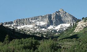
Mount Fitzgerald is the fourth-highest named mountain in the Ruby Mountains and the fifth-highest in Elko County, in Nevada, United States. It is the thirty-ninth-highest mountain in the state. It rises from the heads of both Thomas and Right Fork Canyons (branches of Lamoille Canyon), and is also part of the north wall of Box Canyon, making it a true glacial horn. The summit is a high-level ridge and is located about 24 miles (39 km) southeast of the community of Elko, within the Ruby Mountains Wilderness of the Ruby Mountains Ranger District in the Humboldt-Toiyabe National Forest.
Map of Mt Fitzgerald, Nevada 89815, USA
References
Mount Fitzgerald (Nevada) Wikipedia(Text) CC BY-SA