
Elevation 2,224 m (7,297 ft) Parent range Erymanthos Country Greece | Pronunciation Greek: [eˈrimanθos] Easiest route fly | |
 | ||
Location West central Achaia, 40 km south of Patras | ||
Anverra film production mount erymanthos 2224 greece journey to the sun 12 12 2014
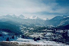
Erymanthos (Greek: Ερύμανθος, Latin: Erymanthus, also Olonos (Ωλονός)) is a mountain range in the southern part of Achaea and the northeastern part of Elis. With an elevation of 2,224 meters, it is the fourth-tallest mountain in the Peloponnese peninsula. The summit is located on the boundary of Achaea and Elis. Historically, Mount Erymanthos was part of northwestern Arcadia, where it was the second-tallest mountain range. The northern portion belonged to the historic Achaea.
Contents
- Anverra film production mount erymanthos 2224 greece journey to the sun 12 12 2014
- Map of Erimanthos Oros Tritaia 250 15 Greece
- Places located near the mountain
- Places on the Mountain
- Geography
- Description
- Panorama
- History
- References
Map of Erimanthos Oros, Tritaia 250 15, Greece
Places located near the mountain
Places on the Mountain
Geography
Mount Skollis is to the west, and many smaller mountains are to the north. Stretching east and southeast is Chelmos, also known as Aroania, which is the name of both a mountain and a village. Chelmos, which can be seen from the mountain, is located to the east, but stretches to the south. The villages of south area of Panachaiko and Omplos are located in an agriculturally rich valley between the peaks of Erymanthos.
Description
The elevation ranges from 150 metres (490 ft) in the north to up to 800 metres (2,600 ft)-1,000 metres (3,300 ft) in the south. Erymanthos is forested around its edges, the forest cover consisting of pine, olive, cedar, birch, and spruce trees. Barren land and grasslands vary from 1,000 metres (3,300 ft) to 1,600 metres (5,200 ft) and non-vegetated portions continue up to the summit. The mountain's color is derived from the colors of the bedrock, which are brown, butterscotch, and tan. Several dry streams appear on the peak.
Connected mountain ranges include Kallifoni and Lampeia (Divri) to the southwest. Other peaks include Moungila or Mougila (Μουγγίλα) at 2,169 metres (7,116 ft), Profitis Ilias (Προφήτης Ηλίας) at 2,124 metres (6,969 ft), Pyrgakos or Pirgakos (Πυργάκος) at 2,050 metres (6,730 ft), one at 1,923 metres (6,309 ft), I Psili Tourla at 1,891 metres (6,204 ft), Lepida (Λεπίδα) at 1,541 metres (5,056 ft), Melissovouni (Μελισσοβούνι meaning "the mountain of bees") at 1,461 metres (4,793 ft), and Agios Athanasios (Άγιος Αθανάσιος) at 1,219 metres (3,999 ft). The mountain is the source of the Pineios river to the southwest, Selinountas to the east, Erymanthos to the south, and Peiros and Parapeiros to the southeast. It is part of the Oleni-Pindos geological zone.
Panorama
The view from the summit of Erymanthos includes most of the western and northwestern Peloponnese, northern Arcadia, and the hills of eastern Ilia. The mountains of southern Central Greece and the mountains of the islands of Zakynthos, Kefalonia, and Ithaca can be seen on clear days.
History
In ancient times, Erymanthos was famous as the residence of the Erymanthian Boar. In Greek mythology, the King of Arcadia, Lycaon, named his boar Erymanthus, after the mountain. Heracles (Hercules) captured the Erymanthian Boar and brought it back to Eurystheus as one of his 12 labors.
Between the Byzantine Empire and the Greek War of Independence, several villages were founded, including Skiada and Oreino. After World War II and the Greek Civil War, most villages were rebuilt. On February 5, 2008, the mountain was shaken by two earthquakes measuring 5.5 on the Richter scale. One epicenter was in Chalandritsa, and the other was in Farres, outside the range.