
Postcode(s) 5607 | Postal code 5607 | |
 | ||
Mount Dutton Bay is a coastal locality in the Eyre and Western region of South Australia, situated in the District Council of Lower Eyre Peninsula. The name and boundaries were formalised in October 2003 in respect of the long established local name. The locality incorporates three older residential "shack sites": Mount Dutton Bay West, on Dolphin Drive, Mount Dutton Bay East, on Woolshed Drive, and Shelley Beach/Salt Creek, on Shelly Beach Road. It is part of the cadastral Hundred of Lake Wangary.
Map of Mount Dutton Bay SA 5607, Australia
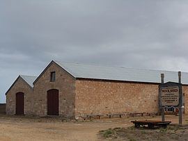
The historic Mount Dutton Bay Woolshed and Mount Dutton Bay Jetty are listed on the South Australian Heritage Register. The woolshed and jetty were built by Eyre Peninsula pastoral pioneer Price Maurice to shear wool from his pastoral leases and transport it to markets; the jetty, the latter of the two, dates from 1881. The site was used as a hub for the wool industry until the 1950s; it has continued as a base for leisure activities thereafter. The woolshed and adjacent shearers' quarters now house tourist accommodation, a museum, cafe and gallery; a caravan park has also been built alongside.
The Mount Dutton Bay Conservation Park is located on islands offshore.