
Prominence 955 m | Elevation 2,296 m Mountain range Siskiyou Mountains | |
 | ||
Similar Pilot Rock, Mount McLoughlin, Roxy Ann Peak, Mount Thielsen, Preston Peak | ||
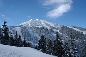
Mount Ashland is the highest peak in the Siskiyou Mountains of southern Oregon. It was named for the city of Ashland, located 8.6 miles (14 km) north of the mountain. The Siskiyou Mountains are in the northern Klamath Mountains in northwestern California and southwestern Oregon. The mountain is part of the Rogue River–Siskiyou National Forest, which encompasses most of the Siskiyou Mountains. The Oregon–California border is 5 miles (8 km) south of the mountain.
Contents
Map of Mt Ashland, Oregon 97520, USA
Geology
Mount Ashland is composed largely of granite, with other igneous intrusive rocks like diorite and granodiorite. The peak and its surrounding flanks make up the Mount Ashland pluton.
Recreation
Mount Ashland Ski Area, located on the mountain, features 23 trails on 200 acres (81 ha) served by four lifts.