
Population 17,472 (2011. Ward) Sovereign state United Kingdom Dialling code 01273 | Unitary authority Postcode district BN2 UK parliament constituency Brighton Kemptown | |
 | ||
University of brighton s moulsecoomb campus facilities and resources
Moulsecoomb is a suburb of Brighton, part of the city of Brighton and Hove. The electoral ward is called Moulsecoomb and Bevendean. It is located on the northeastern side of Brighton, around the A270 Lewes Road, between the areas of Coldean and Bevendean and approximately 2¼ miles (3½ km) north of the seafront. The eastern edges of the built-up area adjoin Falmer Hill, on the South Downs. As the suburb is so large, and developed over an extended period, it is often divided into smaller sections on maps and similar: North Moulsecoomb, East Moulsecoomb and Moulsecoomb itself (also described as South Moulsecoomb).
Contents
- University of brighton s moulsecoomb campus facilities and resources
- Map of Moulsecoomb Brighton UK
- Growing places behind the scenes at the moulsecoomb garden at the cornerstone of local community
- History and development
- Today
- Transport
- References
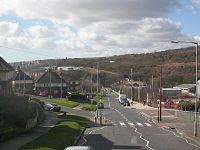
Map of Moulsecoomb, Brighton, UK
The name is sometimes pronounced as if spelled Mools-coomb, though perhaps more often the first part is pronounced like the animal "mole". It derives from the Old English for Muls Valley: Mul was a Saxon nobleman.
It suffers however from high social-deprivation and crime rates. Alongside neighbouring district Whitehawk, it can be considered socially-deprived, in 2001 being considered within the top 5% of socially deprived areas in England.
Growing places behind the scenes at the moulsecoomb garden at the cornerstone of local community
History and development
Before and during the First World War, the land around the Lewes Road was open downland, sloping towards the valley bottom through which the road and railway line ran. The land reached a height of 508 feet (155m) at Falmer Hill, approximately 0.9 miles (1½ km) east of the point where the railway crossed the road on a viaduct. In the valley bottom, some market gardens and small nurseries were maintained.
The South Moulsecoomb area was developed first: the Borough Council acquired land at the existing edge of the built-up area, close to the former Preston Barracks on the Lewes Road, in November 1920 and constructed 478 semi-detached houses with large gardens and three bedrooms each. The "Homes fit for Heroes" campaign, started after the War in response to the poor housing conditions faced by returning soldiers, helped to drive this, but the houses were generally too expensive for the families at whom they were aimed.
The Borough Council responded by acquiring more land, including some from the south end of the neighbouring Falmer parish, in 1922; housing areas began to be developed in this area from 1925 onwards. This was the original North Moulsecoomb area, which at this early stage consisted of four roads named after East Sussex villages (Barcombe, Chailey, Newick and Ringmer) situated between the Lewes Road – then an insubstantial, narrow route between the market gardens – and the railway line. By 1929, 390 houses – smaller and closer together than those of South Moulsecoomb – had been built on the 46-acre (190,000 m2) North Moulsecoomb site.
The South Moulsecoomb part of the estate was extended to the east in the early 1930s using land acquired from Lower Bevendean Farm. It is around this area that modern-day Moulsecoomb merges into the Lower Bevendean estate. After this, more land was acquired in December 1935 to extend development at the northern end to the eastern side of the railway. This area is now known as East Moulsecoomb. At first, housing spread northwards from the Higher Bevendean infill estate (an area of private housing developed at the same time as the South Moulsecoomb extension, immediately north of it), with Shortgate Road being the northern limit before the Second World War; after the War, the last few roads were developed, mostly with small blocks of flats.
The main purpose of such large-scale residential development was to rehouse residents who lived in slums in central Brighton; at that time, much of the residential accommodation in the inner-city area was of poor quality, and slum clearance would allow redevelopment to start as well as taking people out of inadequate, substandard and sometimes dangerous houses.
Moulsecoomb's road network, especially that built later in the East and North Moulsecoomb areas, generally follow the contours of the land rather than being in, for example, a grid pattern, and is characterised by large grass verges and a large land area for each house – many have both front and back gardens. While Moulsecoomb originally consisted exclusively of council housing, owned and operated by the council on behalf of the residents, the right to buy scheme, first implemented in the 1980s, has seen many houses pass into private ownership.
Today
The Moulsecoomb Campus of the University of Brighton is one of the university's three main sites. The 10-storey Cockcroft building dominates most views in the area. As well as teaching facilities, the majority of the university's administration departments are located here, along with some student halls of residence. Moulsecoomb Place, the oldest non-religious building in Brighton, is currently used by the accommodation and counselling services of the university. Before the university was founded in 1992, the various buildings were part of Brighton Polytechnic and before 1970 the Cockcroft Building was the main building of Brighton College of Technology.
Moulsecoomb is also the location of the Home Farm Business Park, where the United Kingdom subsidiary of United States arms manufacturer EDO Corporation is based. This factory has been the site of regular anti-war demonstrations since 2004.
Moulsecoomb Wild Park is a large downland valley which has been preserved in its undeveloped state. It lies immediately to the west of the railway line and the Lewes Road, and merges into the Hollingbury Camp hill fort to the west and the edge of Coldean to the north. There are areas of chalk grassland and woodland and a nature trail. It is more notoriously known for the unsolved 'Babes in the wood' murders.
The "Moulsecoomb Family Fun Day" has been held in the park on the third Saturday in May every year since 1978.
Moulsecoomb Primary School is leading the way in outdoor education with award winning school grounds. They have built a chalk house], the first one built in Britain for 5,000 years to compliment their Saxon, Mesolithic and Iron Age Roundhouse.
Moulsecoomb Forest Garden and Wildlife Project is an award winning community project that offers volunteer opportunities to local residents and pupils who learn best by practical hands-on activities.
The Bevendean Pub in Moulsecoomb opened in December 2014 and became the first co-op pub on a housing estate in the UK.
Moulsecoomb is home to St Andrew's Church, opened in 1934 to be the Church of England presence on the estate.
Transport
Moulsecoomb has a railway station, located on the East Coastway Line. Direct destinations include central Brighton and another major campus of Brighton University at Falmer. The main access road runs uphill from the Lewes Road alongside the Cockcroft Building.
East Moulsecoomb is the eastern terminus for Brighton & Hove Bus Company route 49, which runs from Portslade station via the city centre. This is one of the five METRO-branded routes. At peak times, buses run every 10 minutes. The terminus of the route is the junction of Moulsecoomb Way and Bolney Road (the photograph in the first paragraph was taken from a bus at this stop). Many other bus routes serve various stops on the Lewes Road – notably route 25, another METRO route, which runs to the Falmer Campus of the University of Brighton.