
 | ||
Motukawanui Island is an island in the Bay of Islands of New Zealand, and is located approximately four kilometres northeast from Matauri Bay. It is the largest island amongst the Cavalli Islands group and has an area of 3.40 square kilometres.
Contents
Map of Motukawanui, Cavalli Islands, New Zealand
History
The island had a large Maori population when Captain Cook visited the island group in 1769. The large number of pits and terrace sites, middens and cultivations all suggest a substantial population existed on the island.
Geography
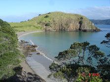
The highest point of the island reaches an altitude of 177 metres. Parts of the island was farmed up until 1974 and the pastoral grassland is now being left to generate into native vegetation and many stands of Kanuka and Manuka are already giving protection to a variety of young native trees.
The shores of Motukawanui are endowed with a great variety of marine life. Papatara Bay is a safe anchorage in most weather conditions and although most of the coastline is rugged, there are some pleasant sand and shingle beaches around the island.
Wildlife
Motukawanui Island is a flourishing breeding ground for the North Island Brown Kiwi since the island was cleared of predators namely possums and mustelids.