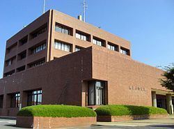
- Tree Yuzu Local time Sunday 12:56 PM | Region Kantō Population 37,171 (Feb 2016) | |
 | ||
Weather 16°C, Wind NW at 14 km/h, 43% Humidity Colleges and Universities Saitama Medical University, Nihon Institute of Medical S, Saitama Medical University | ||
Moroyama (毛呂山町, Moroyama-machi) is a town located in Iruma District, Saitama Prefecture, in the central Kantō region of Japan. As of 1 February 2016, the town had an estimated population of 37,171 and a population density of 1090 persons per km². Its total area was 34.07 square kilometres (13.15 sq mi).
Contents
- Map of Moroyama Iruma District Saitama Prefecture Japan
- Geography
- Surrounding municipalities
- History
- Economy
- Education
- Railway
- Highway
- Local attractions
- Noted people from Moroyama
- References
Map of Moroyama, Iruma District, Saitama Prefecture, Japan
Geography
Located in central Saitama Prefecture, Moroyama is approximately 50 kilometers from downtown Tokyo. Approximately 40 percent of the town area is forest and mountains.
Surrounding municipalities
History
The area around Moroyama has been inhabited since at least the Jomon period, and numerous archaeological sites are within the town limits.
Moro village was created within Iruma District, Saitama with the establishment of the municipalities system on April 1, 1889. Moro merged with neighboring Yamane village to form the town of Moroyama on April 1, 1939. Moroyama annexed neighboring Kawakado village on April 1, 1955. Road paving and housing developments in the early 1960s brought urbanization, population growth and change to areas previously devoted to mulberry fields. This new urban environment led to changes in the industrial structure including decreases in the agricultural population and an increase in the manufacturing and service industries.
Economy
Moroyama remains largely an agricultural town, although it has increasing become a bedroom community.
Education
Railway
Highway
Moroyama is not served by any expressways or national highways
