
Population 56,454 (Feb 2016) | Region Kantō Area 47.48 km² Local time Saturday 11:29 AM | |
 | ||
Weather 10°C, Wind N at 14 km/h, 51% Humidity University | ||
Hidaka (日高市, Hidaka-shi) is a city located in southern Saitama Prefecture, in the central Kantō region of Japan. As of 1 February 2016, the city had an estimated population of 56,454 and a population density of 1190 persons per km². Its total area was 47.48 square kilometres (18.33 sq mi).
Contents
- Map of Hidaka Saitama Prefecture Japan
- Geography
- Surrounding municipalities
- History
- Economy
- Education
- Railway
- Highway
- Sister city relations
- Local attractions
- References
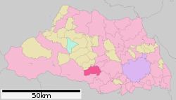
Map of Hidaka, Saitama Prefecture, Japan
Geography
Hidaka is located in south-central Saitama Prefecture.
Surrounding municipalities
History
The area of modern-day Hidaka was part of ancient Koma District, mentioned in records dating from 716 AD as a place of resettlement for refugees from the Tang invasion of the Kingdom of Goguryeo on the Korean peninsula in 668 AD.
During the Edo period, the area developed as Takahagi-shuku, a post station on the Nikkō Wakiōkan highway linking Edo with Nikkō. The three villages of Komagawa, Koma and Takahagi were established within Koma District with the establishment of the municipalities system on April 1, 1889. In 1896 Koma District was abolished, becoming part of Iruma District. On February 11, 1955 Komagawa and Koma merged to create the town of Hidaka. Takahagi joined Hidaka on September 20, 1956. Hidaka was elevated to city status on October 1, 1991.
Economy
The economy of Hidaka remains primarily agricultural, with some light manufacturing. A number of housing districts have been built near the train stations, as the city is increasing a bedroom community for Tokyo metropolis to the south.