
Established 1750 Area code(s) +53 33 Area 615.1 km² | Founded 1543 Time zone EST (UTC-5) Elevation 7 m Population 64,661 (2010) Local time Sunday 4:36 AM | |
 | ||
Weather 20°C, Wind N at 8 km/h, 85% Humidity | ||
Hotel playa coco all inclusive mor n cuba caribbean islands 4 stars hotel
Morón is a city and a municipality in Ciego de Ávila Province in central Cuba. It is one of ten municipalities in the province, and is the second in importance and the oldest. Morón is the closest city to the tourist resorts on Cayo Coco and Cayo Guillermo.
Contents
- Hotel playa coco all inclusive mor n cuba caribbean islands 4 stars hotel
- Map of Moron Cuba
- Geography
- Economy
- History
- Demographics
- Notable residents
- References
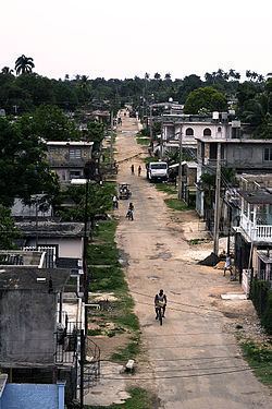
Map of Moron, Cuba
Geography
The municipality is located north of the city of Ciego de Ávila, bordering the Bolivia municipality to the east, Chambas to the west, the Bay of Buena Vista and the Jardines del Rey to the north and the Ciro Redondo municipality to the south. The terrain is mostly plain, with small hills to the north, made up of salt domes. The north shore is covered by marshes.
Morón has the largest natural water mirror in Cuba, Laguna de Leche, of 67.2 km2 (25.9 sq mi). Cayo Guillermo, one of the cays of Jardines del Rey archipellago is located north of Morón, across the Bay of Dogs (Bahia Perros).
The northern highway (Carretera del Norte) passes through the city; the main road from Ciego de Avila to Cayo Coco also skirts it. It is also linked by railway, to Ciego de Avila, and on the Santa Clara-to-Nuevitas line.
Previously the municipality was much larger, being one of nine in the previous province of Camaguey. In 1943, it was divided into the barrios of Coronel Hernández, Chambas, Cupeyes, Este, Guadalupe, Mabuya, Marroquí, Oeste, Punta Alegre, Ranchuelo, Santa Gertrudis, Simón Reyes o Sandoval and Tamarindo.
Economy
The main economic activities are agriculture and tourism.
History
The first residents of Morón were Creoles from Sancti Spiritus, although among them were also said to be a group of Spanish sailors who, having navigated all around Cuba, had disembarked nearby and had decided to settle here. They were from Andalusia, in Old Castile, Extremadura, Galicia and the Canary Islands, among other places.
In the first half of the 20th century, the archipelago and the nearby keys had attained little development. The town of Morón, which started as a community in 1750, survived on a basis of a limited, non-mechanized agricultural, and mostly sugar, production. The settlement pattern that prevailed in the coastal areas and keys was that of squatters, people living in very poor, tach-roof, earth floor dwellings, usually not more than five houses together.
Making charcoal and fishing, in many cases both activities at the same time, were apparently the main economic activities on the keys and their surroundings. Fishing was mostly done by using dinghies moved by sticks, oars, or small sails, which did not allow them to venture out of the key shelf. This means were the ones used also to reach the mainland and to transport products out. In the settlements, livestock was mostly limited to a few animals. Still standing at some places are remains of the stone fences that were used to confine the animal.
Living conditions here were in general very difficult, due mostly to the remoteness of the area and the lack of proper means of transportation. Transportation consisted usually of a small sailboat that traveled back and forth once a month, and whose journey took many hours, Reaching the mainland from Cayo Coco, for example, took around 10 hours, in addition to the risks that had to be run at sea.
During Cuba's 1st War of Independence in 1869, the town of Morón became the northern end of the line of forts, the Trocha from Júcaro to Morón built by the Spanish to contain Cuban rebels on the eastern end of the island. The Trocha also included a railroad line to move troops and supplies, the first government railroad line in Cuba.
The town of Morón began to grow in 1915 when the Trocha rail line was bought by Colonel Jose M. Tarafa as he began to assemble the Ferrocarriles del Norte railway line. Morón was chosen as the line's headquarters. The railway's maintenance shops and a large central station became the central feature of the town. Morón became the junction of a network of several branchlines and sugar lines which stimulated the expansions of sugar plantations and centralized sugar mills which previously were located mainly in the south and central part of Cuba.
In the 1960s a road was built through the marshland to the coast, and in the 1990s this was extended on a man-made causeway to Cayo Coco and Cayo Guillermo, where a number of hotels were built. Many of the hotel workers live in Morón and commute to work in specially provided buses.
Demographics
In 2004, the municipality of Morón had a population of 60,612. With a total area of 615 km2 (237 sq mi), it has a population density of 98.6/km2 (255/sq mi).