
Average depth 2.5 m (8 ft 2 in) Surface elevation 5 m Mean depth 2.5 m | Surface area 2,000 m (0.49 acres) Max. depth 5 m (16 ft) Area 2,000 m² | |
 | ||
Similar Buada Lagoon, Anibare Bay, Command Ridge, Meneng Stadium, Linkbelt Oval | ||
History
During World War II, Moqua Well was the primary source of drinking water for inhabitants of Nauru. It is for this reason that the body of water is referred to as a well instead of a lake.
In 2001, Nauruan authorities decided to put up a fence to prevent accidents, after an alcohol-related drowning in the same year.
Location
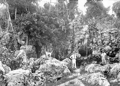
The well is located below the Yaren district. The Moqua Well is not well known, one of a few attractions in Nauru.
Linguistic disambiguation
The name of the well 'Moqua' (sometimes referred to as 'Makwa') is derived from the former name by which Yaren was known.
Other feature
Nearby are the Moqua Caves, a series of underground caves below Yaren.
References
Moqua Well Wikipedia(Text) CC BY-SA