
Population 22,792 (2011) Post town LEEDS Dialling code 0113 | ||
 | ||
Region | ||
Moortown is an affluent suburb of Leeds, West Yorkshire, England in the LS17 postcode area. It is a civil parish and electoral ward in the north of the city. It is situated between Roundhay and Gledhow on the east and Weetwood on the west, with Chapel Allerton to the south, and Alwoodley to the north. It is essentially synonymous with Moor Allerton, and institutions in the area use either name. Moortown lies in Leeds 17 which was reported to contain the most expensive housing area in Yorkshire and the Humber by The Times.
Contents
- Map of Moortown Leeds UK
- General description
- Black Moor and Cranmer Bank
- Lingfield
- Queenshill
- Leafield
- Darkwood
- Moortown Corner
- Moor Allerton District Centre
- Religions
- St Gemmas Hospice
- Sport
- Government
- References
Map of Moortown, Leeds, UK
General description
The suburb is around the junction of the (north-south) Harrogate Road A61 road and the Leeds Outer Ring Road (A6120) (west-east), at that point called the Moortown Ring Road, and overlooked by a Water Tower. Scott Hall Road (A61) and Harrogate Road lead southwards to Leeds city centre. However, the council ward boundary is the Ring Road, with properties to the north now being in the Alwoodley ward. The Church of England parish includes areas north of the Ring Road. A set of woods north and south of the Ring Road and by the water tower are called the Moortown Plantation.
It includes small estates of council housing around the junction of King Lane and the Moortown Ring Road.
Black Moor and Cranmer Bank
To the north of the ring road and west of King Lane is the Black Moor and Cranmer Bank estate, named after the moor on which Moortown was situated. This has varied housing from the 1950s to recent along Black Moor road. There is a parade of shops on Cranmer bank as well as Moortown Social Club at the top of the hill, along with St Stephen's Church (C of E). The main areas on the estate are Blackmoor, Tynwald, Deanswood, Scotland Wood, Cranmer Bank, Alderton and Saxon.
Lingfield
To the north of the ring road and east of King Lane is the Lingfield housing estate comprising mainly semi-detached tenant properties and council flats.
Queenshill
To the south of the ring road and east of King Lane is the Queenshill estate, mainly low-rise flats which was opened in 1962 by Sir Keith Joseph. This area contains a small row of shops, a fire station, Moortown Baptist Church, and the offices of the Leeds Jewish Housing Association.
Leafield
A smaller development of public housing is the south of the ring road and west of King Lane, essentially in the grounds of a former mansion, now Leafield Clinic, where the Leeds North Clinical Commissioning Group's offices are located.
Darkwood
A small 1990 development low-rise flats off Shadwell Lane, in woods known as Blackwoods, part of the Forest of Leeds. The property was originally a large private estate called "Blackwood". It was acquired by the City of Leeds sometime prior to 1963 and converted into several large flats with the extensive grounds preserved until the subsequent development of low rise flats in the 1990s.
Moortown Corner
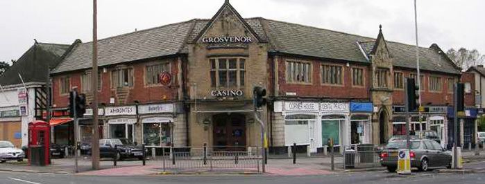
Moortown Corner is the junction between Street Lane and Harrogate Road, a local shopping area and geographical reference. The building known as the Corner House was built as a cinema (1938–1940), ballroom and restaurant but now contains shops. From 1968 to 2008 it contained a casino. Nearby is a large Marks and Spencer Simply Food supermarket which serves the surrounding area. Branches of Leeds Building Society, Yorkshire Bank and Halifax can also be found at Moortown Corner.
Moortown Corner is served by First Leeds service 2, which is represented red on the 10-minute frequency Overground network. Less regularly, services 7a, 7s, 38, and 48 run through Moortown Corner. Harrogate Bus Company's route 36 also serves Moortown Corner between central Leeds and Harrogate every 20 minutes. The image in the photograph appears to be not the junction of Street Lane and Harrogate Road, but rather Shadwell Lane and Harrogate Road. This is actually a short distance North of the Street Lane junction which most Leodensians would recognise to be the true Moortown Corner.
Moor Allerton District Centre
Moor Allerton District Centre is adjacent to the Black Moor estate, north of the Ring Road and west of the junction with King Lane, which opened in 1982. It includes a public library.
However it is mainly a shopping centre, with a large Sainsbury's, and a Homebase. It includes a public house, the Penny Fun, whose name relates to the history of the area as follows. The word 'pen' comes from the Celtic for 'hill'. What is now Tunnel How Hill is visible from the Centre to the south-west. It was previously Pen-how-fyn, and a hamlet around what is now the Centre was Paenfynaen (where fynaen means settlement). Tunnel How Hill was referred to as Penny Fun in the 19th century and several houses in the vicinity used the name. There is a Penny Field nearby in Meanwood Park.
Religions
Moortown and neighbouring Alwoodley are the main centres of the Leeds Jewish Community. There are three synagogues in the Moortown area. The Marjorie and Arnold Ziff Community Centre opened in 2005, providing facilities for the Jewish community in Leeds and district, with the only Kosher restaurant in Leeds and providing offices for some Jewish organizations. The Church of England parish church is St John the Evangelist on the corner of Harrogate Road and the Ring Road; the Catholic one is the Immaculate Heart of Mary Church. There is also a Baptist church on King Lane. A Muslim community centre has been set up in a former pub on Lingfield Hill.
St Gemma's Hospice
Moortown is home to St Gemma's Hospice. This is situated to the south of Moortown Corner on Harrogate Road. St Gemma's Hospice have many charity shops around Leeds, assisting funding for the hospice, with branches in Alwoodley, Beeston, Boston Spa, Chapel Allerton, Cross Gates, Garforth, Guiseley, Halton, Horsforth, Ilkley, Morley, Oakwood, Otley, Pudsey, Roundhay, West Park, Wetherby and Yeadon. St Gemmas Hospice also have a furniture shop on Harrogate Road.
Sport
There is a Rugby Union football club. Moortown Golf Club hosted the 1929 Ryder Cup, but is well North of the Ring Road and is now in the Alwoodley ward. Moor Allerton Sports and Social Centre [1] has bowls, tennis and indoor activities.
Government
As of May 2015 there are three Labour Councillors and one Labour MP that are responsible for raising concerns / issues from the Moortown Community.