
Population 1,978 (2011 census) Postcode(s) 5558 State electorate(s) Goyder Postal code 5558 | Established 1999 Time zone ACST (UTC+9:30) Founded 1999 Local time Saturday 10:26 PM | |
 | ||
Weather 19°C, Wind E at 18 km/h, 43% Humidity Lga District Council of the Copper Coast | ||
Moonta Bay is located in the Copper Coast region of Northern Yorke Peninsula South Australia, adjacent to the historic town of Moonta and Port Hughes. At the 2006 census, Moonta Bay had a population of 2,042.
Contents
Map of Moonta Bay SA 5558, Australia
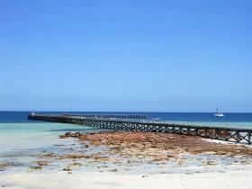
It is a popular tourist destination, with attractions including the beach and jetty.
Accommodation is available for tourists at the beachside caravan park and motel. There are a range of restaurants, cafes and a functions venue.
The function centre located on the headland overlooking the sea is a popular location for weddings.
The historic Rossiters Point Saltwater Intake and Pumping Station is listed on the South Australian Heritage Register.
Governance
Moonta Bay is located within the federal Division of Grey, the state electoral district of Goyder and the local government area known as the District Council of the Copper Coast.
Swanky beer
Moonta Bay is the home of Copper Coast Wines, the producer of the traditional Swanky beer.