
Parent range Central Apennines Province Province of Frosinone | Elevation 2,249 m Mountain range Apennine Mountains | |
 | ||
Similar Monte Meta, Matese, Monte Cairo, Monte Greco, Maiella | ||
Monti della meta 2242m e monte tartaro 2191m pnalm 29 07 16
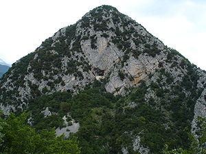
The Monti della Meta are a massif of central Italy located around the junction point of the boundaries between the regions of Lazio, Abruzzo and Molise. The major of three massifs of the Parco Nazionale d'Abruzzo, Lazio e Molise, they take their name from one of the peaks, Monte Meta.
Contents
- Monti della meta 2242m e monte tartaro 2191m pnalm 29 07 16
- Map of Monti della Meta 03040 Picinisco Province of Frosinone Italy
- 7 trail monti della meta
- OverviewEdit
- References
Map of Monti della Meta, 03040 Picinisco, Province of Frosinone, Italy
7 trail monti della meta
OverviewEdit
The massif covers a map area of about 93.29 km2 (36.02 sq mi), with a minimum altitude of 450 m (1,480 ft), a maximum altitude of 2,249 m (7,379 ft) and a mean altitude of 1,000 m (3,300 ft).
All the highest peaks (including the Monte Petroso, 2,247 m, Monte Cavallo, 2,039 m and Monte Mare, 2,020 m) show traces of Quaternary glaciation. Valleys in the chain include those of the Melfa and Mollarino rivers in the province of Frosinone, and the Rio Torto in the province of L'Aquila.
The southern part of the massif, on the boundary between Molise and Lazio, is the Monti delle Mainarde. Here, historically, the human presence has been not seasonal as in the highest slopes.