
Last eruption unknown Elevation 1,482 m | First ascent unknown Easiest route Hiking | |
 | ||
Mountain type Stratovolcano (extinct) Similar Pico do Fogo, Monte Fontainhas, Monte Gordo - Cape Ver, Monte Verde - Cape Ver, Pico da Antónia | ||
Monte Velha (Portuguese meaning the old mountain) is a mountain in the northeastern part of the island of Fogo in Cape Verde. At 1,482 m elevation, it is the island's third highest point. It is located between Chã das Caldeiras north of the northern part and is inslde the municipality of Mosteiros, other places within the mountain include Feijoal. It has one of the most important forest reserves in the country. It has path accessible to the hikers connecting the caldeira and the Atlantic.
Contents
Map of Monte Velha, Cape Verde
Up above, it has panoramic views of much of the northeast of Fogo and the western part of the island of Santiago, Maio can almost cannot be seen.
Topography
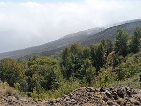
Its topography compares to the volcano of Pico do Fogo, Monte Velha characterizes by steep slopes dominating about 30% of the area between the summit and the sea.
Climate
Due to the exposure of northeast winds, Monte Velha is being the most humid part of the island, it features different vegetation. It has a precipitation season located at the altitude of 1,300 meters, it observes monthly rainfalls and reval important differences. For an example, the yearly precipitation between 1970 and 1988 measured in Feijoal and Mosteiros, at an altitude of 285 m and by the coast, 322.4 millimeters was measured in Patim located on a semi-arid part of the south coast at the elevation of 535 meters, received only 162.6 However, the Portuguese geographer Orlando Ribeiro studied the volcano area in the 1950s just before the 1951 eruption., rainfall amount measured at 1,037 mm on the mountain compared to 509 mm at Feijoal. A German thesis compared the irregularities in 2000 with 383.6 mm in 1998, 1,480 in 1999 and 1,457 in 2000.
Environmental protection
Trees includes eucalyptus, pines, mimosas, lemon and cypresses, it is protected as part of Monte Velha Forest Perimeter (Perímetro florestal de Monte Velha) which covers 850 hectares of land located at an altitude of 1,000 meters and includes the summit.
The nature reserve was suffered by a few forest fires. In 2004, 300 hectares was destroyed, a third of the area. On April 23, another forest fire but smaller destroyed 80 hectares, about 6% of the forest perimeter, it affected the area rich in endemic plants including Euphorbia tuckeyana, lantisk (lantisco) (Periploca chevalieri), losna (Artemisia gorgonum), erva-cidreira (Satureja forbesii), cravo-bravo (Erysimum caboverdeanum). With the help of rainfall, reforestation campation started in early August 2011.
History
The mountain was larger and less slopy until the gigantic eruption of 73,000 BC that sunk the northeast part into the ocean.