
Prominence 637 m | Elevation 2,964 m Province Province of Turin | |
 | ||
Listing Alpine mountains 2500-2999 m Similar Corno Bianco, Cima Carnera, Punta Grober, Massa del Turlo, Monte Bo | ||
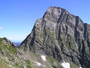
Monte tagliaferro mt 2964 13 09 2012 val sermenza monte rosa
Monte Tagliaferro is a mountain of the Pennine Alps. It is one of the most popular hiking destination of Valsesia.
Contents
- Monte tagliaferro mt 2964 13 09 2012 val sermenza monte rosa
- Map of Monte Tagliaferro 10031 Borgomasino Metropolitan City of Turin Italy
- Monte tagliaferro
- EtymologyEdit
- GeographyEdit
- SOIUSA classificationEdit
- Access to the summitEdit
- MapsEdit
- References
Map of Monte Tagliaferro, 10031 Borgomasino, Metropolitan City of Turin, Italy
Monte tagliaferro
EtymologyEdit
The name, which literally means iron cutting, may come from a sharp stone block located not far away from the top.
GeographyEdit
The mountain is located in Valsesia (VC, Piemonte region). Administratively it is divided between the comunes of Alagna Valsesia and Rima San Giuseppe.
SOIUSA classificationEdit
According to the SOIUSA (International Standardized Mountain Subdivision of the Alps) the mountain can be classified in the following way:
Access to the summitEdit
The easiest route for the summit starts from Rima San Giuseppe and reaches the summit passing through Vallarolo pass (2,332 m). Nearby the mountain, at 2,264 m, is located Rifugio Ferioli, a public mountain hut.
MapsEdit
References
Monte Tagliaferro Wikipedia(Text) CC BY-SA