
Mountain type Stratovolcano | Elevation 405 m | |
 | ||
Similar Monte Estância, Monte Gordo - Cape Ver, Pico da Antónia, Topo da Coroa, Rocha Estância | ||
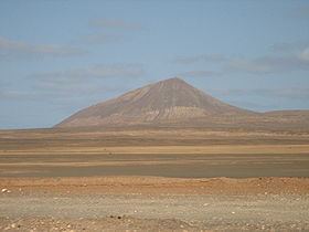
Monte Grande (Portuguese meaning “big mountain”), also known as Monte Vermelho is a mountain in the northern part of the island of Sal in Cape Verde. It is situated 8 km northeast of the island capital Espargos. At 405 m elevation, it is the highest point of the island. It is a protected landscape because of its geological value, its area covers 1,320 ha and the boundaries are 16.569 km long.
Map of Monte Grande, Cape Verde
Two or three track roads connect the mountain. It geology are made up of recent volcanic material, notably with the presence of pillo lavas in the western side. This kind of feature exists on some other islands. Nearby peaks includes Monte Sal (309 m), a small hill formation in the west is Morrinho de Açúcar.
The geology consists of the Monte Grande-Pedra Lume formation which consists of olivine nephelite rocks and olivine melilithite rocks, its rocks were formed around 4.5 to 1.06 million years ago.