
Country Italy Frazioni Valle di Teva Demonym(s) Cerignonesi Local time Saturday 12:39 AM Patron saint Saint Blaise | Elevation 528 m (1,732 ft) Time zone CET (UTC+1) | |
 | ||
Weather 9°C, Wind S at 3 km/h, 54% Humidity Province Province of Pesaro and Urbino | ||
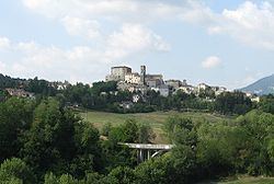
Monte Cerignone is a comune (municipality) in the Province of Pesaro e Urbino in the Italian region Marche, located about 90 kilometres (56 mi) northwest of Ancona and about 40 kilometres (25 mi) west of Pesaro.
Contents
- Map of 61010 Monte Cerignone Province of Pesaro and Urbino Italy
- Festa medievale di monte cerignone 2011
- References
Map of 61010 Monte Cerignone Province of Pesaro and Urbino, Italy
Monte Cerignone borders the following municipalities: Macerata Feltria, Mercatino Conca, Montecopiolo, Monte Grimano, Sassocorvaro, Tavoleto.
Sights include the Malatesta fortress, which was partly designed by Francesco di Giorgio Martini.
The town has the head office of the coffeeshop chain Caffè Pascucci.
Festa medievale di monte cerignone 2011
References
Monte Cerignone Wikipedia(Text) CC BY-SA