
Elevation 594 m | ||
 | ||
Similar Benara, Tahiti plage, Conservatoire botanique national d, Mount Karthala | ||
Mayotte lever du soleil sur le mont choungui
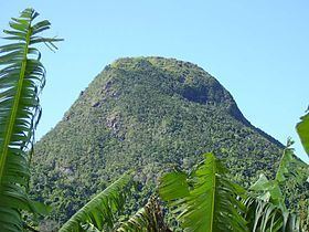
Mont Choungui is a distinctively conical volcanic mountain in the southern part of the French island of Mayotte, in the Comoro archipelago of the western Indian Ocean. It is the second highest point of the island at 593 m (1,946 ft), the highest being Mont Bénara, and is visible from far out at sea.
Contents
- Mayotte lever du soleil sur le mont choungui
- Map of Mont Choungui Mayotte
- Mont choungui avec les thugs
- Important Bird Area
- References
Map of Mont Choungui, Mayotte
Mont choungui avec les thugs
Important Bird Area
Choungui dominates the southern peninsula of the island. Its south-easternmost headland, Sazilé, is 4 km long with a sharp ridge rising to 233 m. Forest covers the peak and most of the catchment of the Mroni Bé river, while Sazilé is vegetated with dry shrubland and thickets containing baobabs. The 1600 ha site has been identified as an Important Bird Area (IBA) by BirdLife International because it supports significant populations of Comoro olive-pigeons, Comoro blue-pigeons, Mayotte white-eyes, Mayotte sunbirds and red-headed fodies. It is also home to Robert Mertens' day geckos, island day geckos and Pasteur's day geckos. Sazilé’s beaches are a nesting site for green, and probably hawksbill, sea turtles.