
Length 258 km Bridges Pedro e Inês bridge | Country Portugal | |
 | ||
O rio mondego transborda mondego river overflows
The Rio Mondego ([mõˈdeɡu]; English language: Mondego River) is the longest river located exclusively in Portuguese territory. It has its source in Serra da Estrela, the highest mountain range in mainland Portugal (i.e. except the Portuguese islands). It runs 234 kilometres (145 mi) from the Gouveia municipality, at 1,425 metres (4,675 ft) above sea level in Serra da Estrela, to its mouth in the Atlantic Ocean next to the city of Figueira da Foz.
Contents
- O rio mondego transborda mondego river overflows
- Map of Mondego River Portugal
- TributariesEdit
- References
Map of Mondego River, Portugal
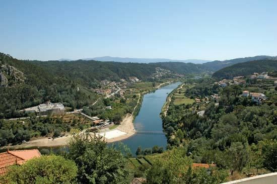
It flows through the districts of Guarda, Viseu and Coimbra, all in Centro Region. It flows near the towns of Celorico da Beira, Fornos de Algodres, Nelas, Tabua, Carregal do Sal, Mortagua, Montemor-o-Velho and cities of Seia, Gouveia, Guarda, Mangualde, Santa Comba Dao, before crossing the town of Penacova, is narrow, then widens by the city of Coimbra (with the University and the major urban area in Baixo Mondego), and the Montemor-o-Velho municipality (known for its castle and rice fields), before reaching the Atlantic at the city of Figueira da Foz.
There are 2 dams along the Mondego: Aguieira dam and Raiva dam.
TributariesEdit
One of its tributaries is the Rio Dão, which gives its name to the Dão DOC wine region. The Ceira River enters the Mondego just south of Coimbra along NH 17.