
Elevation 864 m (2,835 ft) Time zone CET (UTC+1) | Demonym(s) Molvenesi Local time Thursday 1:24 AM | |
 | ||
Region Trentino-Alto Adige/Südtirol Weather 5°C, Wind N at 23 km/h, 50% Humidity Points of interest Brenta group, Paganella Molveno, Cima Brenta | ||
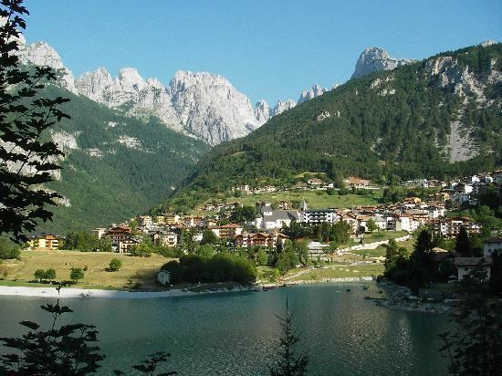
Molveno is a comune (municipality) in Trentino in the northern Italian region of Trentino-Alto Adige/Südtirol, located about 40 kilometres (25 mi) northwest of Trento.
Contents
Map of 38018 Molveno, Province of Trento, Italy
Geography
Molveno is located at the northern end of a 4-kilometre (2.5 mi) long lake (Lago di Molveno), at the foot of the Brenta Group and the Paganella mountain.
The Lake of Molveno, formed by a landslide about 4000 years ago, is the second largest in Trentino-Alto Adige, 3.3 square kilometres (1.3 sq mi). It has a maximum depth of 123 metres (404 ft).
Molveno borders the following municipalities: Andalo, Cavedago, Ragoli, San Lorenzo in Banale, Spormaggiore, Terlago, Tuenno and Vezzano.
History
The area of Molveno is known to have been settled since the Neolithic age. Due to its strategic position at the entrance of the Brenta-Paganella plateau, it was contended between the Bishops of Trento, the counts of Tyrol and the counts of Flavon.
From 1802 to 1805 the Austrians had a series of fortification built on the lake to halt the French troops.