
Intermunic. comm. Médio Tejo Area 6.7 km² Postal code 2380 Area code 249 Municipality Alcanena | Subregion Médio Tejo Patron Santa Maria Population 866 (2011) | |
 | ||
Website | ||
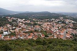
Moitas venda to alcanena portugal
Moitas Venda is a civil parish (freguesia) in Alcanena Municipality, in the Médio Tejo Subregion of Centro Region, Portugal. The population in 2011 was 866, in an area of 6.75 km².
Contents
- Moitas venda to alcanena portugal
- Map of Moitas Venda Portugal
- History
- Geography
- Economy
- Culture
- References
Map of Moitas Venda, Portugal
History
The parish was created on 11 April 1925.
Geography
Moitas Venda is situated between the Serras de Aire and Candeeiros, near the Cabeço de Santa Marta.
The parish includes the locality of Casais Robustos.
The Cabeço de Santa Marta, to the north of the municipality of Alcanena is one of the most important lookouts on the Ribatejo. From the heights of Santa Marta, Moitas Venda has a panoramic landscape, that extends towards the Tagus valley.
Economy
Apart from its current agricultural economy (consisting of olive trees and figs), the parish includes several industrial activities: textiles, oils and tanneries. In addition the Feira Franca Anual (Annual Free Fair) is a popular attraction, that extends from its history, that includes artisans in hides and tannery.
Culture
On the pinnacle of the Cabeço de Santa Marta is the Chapel of Santa Marta (Capela de Santa Marta), a hermitage that was the site of hermits and other religious faithful, who lived and cultivated along the flanks of the hilltops cereal grains and pastures. The chapel was constructed during the Middle Ages, and contain several azulejo tiles, including one of the figure of Saint Marta defeating a dragon.